Wednesday, June 16, 2021

Utah Mighty 5 Road Trip

Tags


Utah is a state located at Central Southwest region of United States. A majority of the land there is dessert like that is dry and hot. Due to Utah's unique environment, it has many unique land formation with breathtaking views. Thus Utah has 5 national parks in total and has attracted thousands of visitors every year. These 5 national parks are Zion, Bryce, Capitol Reef, Canyonlands, and Arches.


We decided to pay a visit to these 5 mighty national parks in Utah. We chose to go there around Memorial Day week because we were thinking that it shouldn't be too hot. But we were wrong. It was still extremely hot.


We first flew to Las Vegas and rented a car from AVIS. AVIS gave us a Mitsubishi Outlander with AWD and it turned out to be a great decision. The Outlander was capable of handling off road conditions without any difficulties.


After we got the car, we went to Albertsons to stock up water. We bought 2 packs of 24 bottles of water and also some fresh fruits. We then headed our way to Zion National Park. By the time we got to the La Quinta hotel that is at Springdale, it was already 6PM. We were quite tired for the day and went to sleep right away.


The second day morning we went to Zion at 6AM and first did Angels Landing hike. Then we did riverside walk at the narrows and went to do Emerald Pool Trail. In the evening, we got takeout from Oscars Cafe.


On the third day, we checked out the hotel and went to Zion Observation Point with amazing view. Then we drove our way towards Bryce National Park. We visited all the view points while we were there and did Bristlecone Loop Trail.


On the fourth day, we went to see sunrise then did the figure 8 hike that includes Navajo Loop Trail and Peekaboo Trail. After the long hiking day, we had dinner at Canyon Diner.


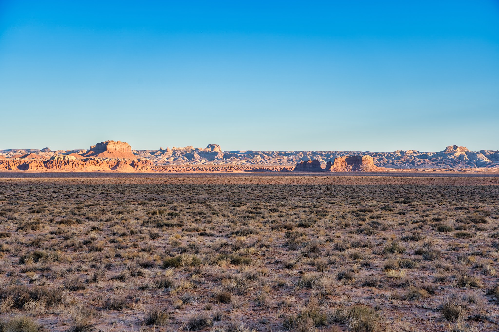
On day 5, we drove to Capitol Reef National Park. We first did the off road drive through Cathedral Valley. It was beautiful. Then we did Hickman Bridge Trail. In the evening, we had dinner at Chak Balam Mexican restaurant.


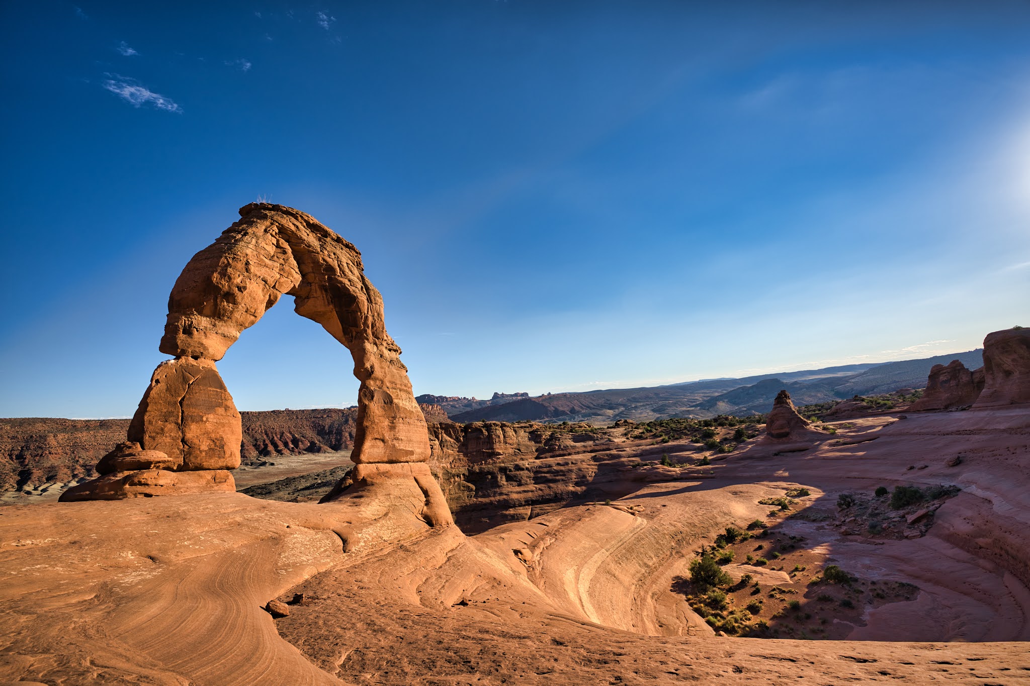
On day 6, we drove to Canyonlands National Park. We did the hike at Grand View Point Trail and Shafer Canyon Overlook Trail. Then it was getting so hot, so we went to grab lunch at Arches Thai. In the late afternoon, we went to Delicate Arch at Arches National Park.


On day 7, we went to Mesa Arch for sunrise. Then we immediately went to Windows Arch and Double Arch. After that we did Devils Garden hike. By noon, we made our way to Monument Valley. On the way there, we passed by Valley of Gods, which was pretty cool. The town of Bluff that we passed by also showed historical fortress by in the 1800s.


On day 8, we enjoyed the sunrise at Monument Valley, It was phenomenon. Then we headed back to Moab and rest there. In the late afternoon, we drove to Arches National Park again just to look around and enjoy the scenery.


On day 9, which is the last day, we made our way to Salt Lake City airport to head back to Portland. This was an amazing trip nevertheless. Switched 5 different hotels and drove across the state of Utah.

Tuesday, June 15, 2021

Shake Shack

Tags


Shake Shack is a popular burger chain originated from New York. Its popularity has grown over the years and even went public with stock offering. Shake Shack offer burgers, fries, hot dog, and milkshake. The Shake Shack location often have line up in front of the store waiting to order food. It is quite crazy.


As part of our Utah trip back home at Salt Lake City Airport, we happened to run into a Shake Shack location. We have always wanted to try Shake Shack when it opened its new location at Beaverton, but it always had a really long line at the store. So this was really a great opportunity for us to try.


We lined up and ordered a Shake Shack Burger, a Shroom Burger, an order of fries with cheese dip, and a chocolate milkshake. After a about 10 minutes, the order was ready.


The Shake Shack Burger was like the usual cheese burger. The beef patty was quite juicy and it was pretty good. We liked it. The Shroom Burger came with fried portobello mushroom, but it was fried which was a surprise to us. The taste was okay on the Shroom Burger, but we preferred Shake Shack Burger of course. The fries were cut with wedges and thick. We liked thicker fries and the cheese dip was warm. We really liked it. The disappointment was on the milkshake. It was such a small cup of milkshake and tasted no different from the one at McDonald's. The price of Shake Shack milkshake is definitely not worth the price.


Overall, Shake Shack was okay We weren't exactly impressed with its burgers and shakes. It really made us think that McDonald's has a really good price on its menu items.

Arches Thai

Tags


Arches Thai is an authentic Thai fine dining restaurant. As its name suggests, it is located near Arches National Park in the town of Moab. It has a large indoor seating area and is ranked as top restaurants in the Moab region on Yelp. During the pandemic time, wear mask is required in order to dine at Arches Thai.


We went to Arches Thai around noon. When we got there, we weren't sure where the parking was at for the restaurant. Thus we did street parking across the road and walked over. The menu was pasted on the wall for takeout customers. However, the menu was a bit high up on the wall, thus it was a bit difficult to read.


We were quite hungry after did all the hiking at Canyonlands National Park. Thus we ordered Pad Thai, Pad Se Ew, Thai Salad, and Spring Roll. Since the restaurant was under staffed, we were told that we might have to wait for 20 minutes.


We sat outside while waiting for our food to be ready. While we were waiting, we saw many additional customers entering the restaurant. It appeared that the restaurant was quite popular and even offer many vegetarian options.


After about 25 minutes, our food was finally ready. We really like the Pad Se Ew, the sauce was simply great with sweetness and the noodle was soft. In contract, the Pad Thai was not as good as what we were expecting. The Pad Thai sauce was a little on the sour side. The Pad Thai noodle was a bit clumped together, although it might due to the hot weather. The Spring Roll tasted as expected and crunchy. The Thai Salad came with tofu in there and peanut butter sauce. We didn't add much peanut butter sauce though, since the salad was fresh enough for good taste.


Overall, Arches Thai was a good Thai fine dining restaurant and a great option for food after a long hiking day.

Arches National Park

Tags


Arches National Park is located at Southeast of Utah. It is located close to Canyonlands National Park beside the town of Moab. Arches National Park is known to have unique looking rocks with shape of an arch. Although Arches National Park is not big, it is actually one of the most popular national park in the state of Utah. It has attracted thousands of visitors each year.


We visited Arches National Park right after visiting Canyonlands National Park. On the first day, we went into Arches National Park around noon just to go to the visitor center and grab some maps and information. It was way too hot at noon and thus we went back to hotel to rest first. The temperature were above 100 degrees for sure.


In the late afternoon when the temperature cooled down a bit, we went to Delicate Arch to check out the legendary Delicate Arch. It was still quite hot at 6PM but we wanted to get there before sunset.


The next day morning, we went to Windows Arch first thing in the morning. There were already many cars in the parking lot but we were able to find a parking space luckily. After that, we walked across the parking lot to check out Double Arch.


After Double Arch, it was around 10AM and it was starting to get hot. We figured that we could do one more hike and thus we went to Devils Garden. When we finished the hike, we were already so exhausted and didn't even want to move an inch anymore.


In the afternoon, we visited Garden of Eden view point. The view point has a grand view over the dessert land in Arches National Park. While we were there, we met 2 people who were doing rock climbing on the Owl Rock there. We stayed a bit and checked them out climbing the rock. They were really good at it and were climbing quite fast on the vertical rock.


Overall, Arches National Park was quite amazing. Its unique landscape and the arches rock formation is quite cool, especially the delicate arch.

Devils Garden

Tags


Devil's Garden is the furthest scenic attraction at Arches National Park. It is all the way at the end of the scenic drive. Devil's Garden trail is quite long, about 8 miles loop distance. Also, some part of the trail are quite difficult for people to climb over the rocks and could be dangerous with vertical drops and fallen rocks. People usually just do the trail all the way to Landscape Arch and go back.


We got to Devil's Garden around 10AM in the morning and it was already so hot. There was plenty of parking space to park the car, so parking isn't a problem. We started to hike the trail and the trail branches off to Tunnel Arch and Pine Arch. The Tunnel Arch is essentially a big circular whole in the wall. Since the hole is quite deep in the wall, it looks like a circular tunnel.


Further down the branched off trail, it leads to Pine Arch. There was less people here and much more quiet. We were not sure why it is called Pine Arch. The Pine Arch essentially look like any arch standing on the ground with a wide opening underneath it.


Going back to the main trail, we ran into the girl that we saw at Bryce National Park. Since the weather was so hot, she also seemed very exhausted and just want to go back. We continued to hike for about 1 mile and got to Landscape Arch. We were only allowed to look at Landscape Arch from afar, but we could see the arch stretching quite far from 1 end of the cliff to another. The arch also looked quite thing from the ground. It was pretty cool to see it. There was also lot of shade at where Landscape Arch is at and many people were taking rest here.


Heading further down the trail, we came to a rocky climb place. The climb was quite steep without any chains. It was a little intimidating and many people chose to stop here and turn back. We looked at the map and decided to turn back as well since there wasn't too much to see further down the trail anymore.


Overall, Devil's Garden was a scenic hike. It was not as cool as Delicate Arch, but it still offer its own uniqueness for people to see. If it wasn't due to the hot weather, we would probably complete the loop.

Double Arch Trail

Tags


The Double Arch Trail is one of the scenic view at Arches National Park in the state of Utah. The trail is quite short, only about 0.1 miles. The trail is located right across from Windows Arch Trail. So people usually do both of them together. But since the same parking lot is shared among these 2 trails the parking lot does get full really fast. Thus it is recommended to get there early.


We went to do Double Arch Trail after Windows Arch Trail. We simply had to walk across the parking lot to get to Double Arch Trail head. The trail at Double Arch was quite sandy but still easy enough to walk on. Thus it is also very family friendly. From the trail head, we could already see the Double Arch far ahead.


At the end of the trail where Double Arch is, we could see 2 arches attached to the same corner of a cliff. Then these 2 arches split out to the separate end of the cliff on the other side. It was quite spectacular. We could also go underneath the arch to get a view from the bottom. It is recommended that to take photos from the bottom so that it captures the blue sky to differentiate the arches from the rock walls.


As we sat there to enjoy the view, 2 groups of tour bus came by and there were so many people all at once. It was so crazy. There were probably 100 people from these 2 tour buses. Since it was getting crowded, we decided to head back and move to the next view point. As we got back to the parking lot, there were 2 tour buses parked at bus only zone with rangers directing the traffic. So when visiting this place, do not park at the bus only parking space.


Overall, the Double Arch is not as spectacular as Windows Arch. However, since it is just right there and a very short hike, it is worth doing the hike to see it.

Monday, June 14, 2021

Windows Arch Trail

Tags


Windows Arch Trail is an easy 1 mile loop trail located in Arches National Park. It is one of the popular trail in the park and many tour bus come here. The parking lot at Windows Arch Trail is not that big and thus the parking lot does get full really fast, especially the parking lot is shared with another hiking trail on the other side. There are 3 arches on Windows Arch Trail. These 3 arches are North Window Arch, South Window Arch, and Turret Arch. All of these 3 arches can be accessed by the hiking trail.


We got to Windows Arch Trail around 8AM in the morning. The parking lot was nearly full and we had to park the car on the other side and walk over. But this is okay since we plan to do the other trail after. When we got to the trail head, we decided to head to North Window Arch first.


The North Window Arch is a better spot for taking photos and it is easy to get underneath the arch. We could also go through North Window Arch to get to the East side and take photo from there. By taking the photo from the East side, we could take a photo with North Window Arch as the frame and Turret Arch being in the middle. It was a perfect natural frame. The only thing to watch out for is that you have to climb onto the top of the rock. Be very careful here and not fall down.


After visiting North Window Arch, the South Window Arch is less spectacular because it is not as round. It was also much harder to get underneath South Window Arch, thus there was nearly no one at South Window Arch.


We then moved to Turret Arch. The Turret Arch formation was quite interesting. Unlike other arches, Turret Arch looks like a door way. The arch was very high up with a large vertical opening underneath it. We could also go through Turret Arch and see the scenery on the other side.


Windows Arch Trail is a must visit and very family friendly. It also doesn't take much time to visit thus people should definitely drop by here when visiting Arches National Park.

Delicate Arch Trail

Tags


Delicate Arch is a world famous photography location. It is located within Arches National Park and the Delicate Arch Trail is the most popular hiking trail is the park. The Delicate Arch Trail is about 3.7 miles round trip with some elevation gains. It is recommended to do this hike early in the morning or late in the afternoon to avoid the hot weather. It can get as hot as 100 degrees during the day.


We got to Delicate Arch trail head around 6PM and it was still so hot. We had to make sure we carry enough water before we start. When we were at the parking lot, there were still many parking spaces but it was filling up fast. Thus we figured that we came at around the right time.


The hiking trail started flat but start to climb a little over the small hill. This was not a big deal. Then the trail came to a rock that requires you to climb upwards. This was the hardest part of the trail. The climb is about 0.5 miles long and many people were going very slowly here. The climb was actually not that difficult and we were able to keep up our pace without taking a break. Once we got to the top of the trail, we saw many piles of rocks lined up nicely on the side.


We continued down the trail through some sandy patches and over the rocks. There were places where the rocky trail was quite narrow and could only allow a single person to pass through. As we were close to get to the end, the trail went around the cliff with vertical drop on 1 side. The trail was only about 2 feet wide. For people with fear of height, it would be better to go when no one is coming from the opposite direction.


Once we got to Delicate Arch, there were so many people there. We weren't expecting such a big crowd. It was crazy. Everyone was there simply to enjoy the sunset. We even saw people resting there waiting for nightfall to come.


We saw there for about an hour to enjoy the breeze and the view. It was quite amazing and we loved it. When it was 8PM, we decided to head back while it was still bright. As we head back, we still see a lot of people coming up. When we got back to the parking lot, the parking lot was full!


Delicate Arch Trail is definitely a must do when visiting Arches National Park!

Monument Valley

Tags


Monument Valley is a world famous site that has awesome scenery at its photographer's view point. Monument Valley is located at Navajo Nation, just within the state of Arizona. It is located near the border of Utah and Arizona, on the Southeast side of Utah. Monument Valley has attracted thousands of visitors each year, but due to pandemic, it has been closed off to visitors for the past year.


Luckily, Monument Valley has opened to visitors if you stay at Valley View Hotel. We happened to have made reservation at Valley View Hotel when visiting Utah. Thus we drove 3 hours South to Monument Valley on this beautiful day and we were excited to see what it brings to us.


On the way to Monument Valley, we passed by the famous movie scene in Forest Gump movie. This was where Forest Gump ran through. It is a super straight road that leads into Monument Valley. Many people pull over and stop by for a photo. Keep in mind that the cars here drive very fast due to the straight road, so make sure to pay close attention to traffic on both directions.


We got to Monument Valley around 4PM and checked in to the hotel. We got a cabin instead.k The cabin has a queen bed, and 2 bunk bed in the small room. The hotel does not offer WIFI unfortunately and it is only available at hotel lobby. Since it was only 4PM, we decided to take a rest before the sunset at 8:30PM. When the time came by, we just realized that Monument Valley was operating in the same time zone as Utah, but not the same time zone as Arizona. Our cellphones automatically sync'd to Arizona time zone. This has caused us to almost miss the sunset.


The sunset at Monument Valley was beautiful. There were many people sitting at the balcony of Valley View Hotel to enjoy the view.


When the night came, we were thinking of heading out to see the stars. Unfortunately it was quite cloudy. We also saw several lightning striking the Monument Valley far away. It was quite crazy.


The next day morning, we woke up early and went to the Valley View Hotel balcony to see the sunrise while drinking coffee. It was quite spectacular. Afterwards, we also picked up our packed breakfast from the gift shop.


Overall, it was quite an experience at Monument Valley. Everything seems so quiet over there and we really enjoyed our time there.

Sunday, June 13, 2021

Canyonlands National Park

Tags


Canyonlands National Park is 1 of the 5 national parks in Utah. It is located Southeast of Utah along with Arches National Park near Moab. Canyonlands National Park has 3 major sections. This includes Islands in the Sky, the Needles, and the Maze. These 3 sections are separated by Green River and Colorado River. Most visitors go to Island in the Sky because it is more accessible. Needles is further out and the Maze simply just require off road vehicles.


We got to Island in the Sky visitor center around 9AM in the morning and there were already many people there. The first place that we visited was Green River Overlook. We could see the canyon carved out by Green River far away. It was a beautiful site as we have never seen such canyon before.


We then drove all the way to the end of the scenic drive at Grand View Point and hiked the Grand View Point Trail. From here, we could see the canyon carved out by Colorado River.


Afterwards, we stopped by the view point for Orange Cliff, but this was not that interesting compared to others. Thus we didn't spend much time here. The next view point was Buck Canyon. This canyon was interesting in a way that it is shaped weirdly like a dagger.


We then went to Shafer Canyon Overlook and had a short hike. The Shafer Canyon used to be a mining area and thus there were roads used for truck to carry out the minerals. We were able to see off road vehicles venturing up and down the canyon.


The next day morning, we woke up extremely early to go to Mesa Arch for sunrise. There was a lot of people there, but the sunrise was beautiful. We really loved it.


Overall, Canyonlands National Park really has its unique landscape that makes the visit totally worth it. We did not do any long hikes here because it was too hot however.

Mesa Arch Trail

Tags


Mesa Arch Trail is probably the most popular hiking trail in Canyonlands National Park. It is a 0.7 miles long loop trail just South of Island in the Sky visitor center of Canyonlands National Park. Although the trail is super popular, the parking lot for this is quite small and can probably only hold 20 cars. Thus people often had to park the car on the side of the road due to the amount of crowd on this trail.


Instead of visiting Mesa Arch during the day, we decided to go there for sunrise. We work up at 4AM in the morning and got to Mesa Arch parking lot around 5:30AM. When we got there, we were shocked with what we saw. The parking lot was essentially full. We were lucky to get the last parking space. We were surprised by the amount of people here this early in the morning.


As we made our way on the trail to Mesa Arch, there were so many people there already. Almost everyone had their tripod and camera set up and just waiting for the sun to rise above the horizon. We weren't able to find a good spot to take any good photo. We simply came too late.


Just as we were thinking of what to do, one young lady moved away from her front row seat and told us we could sit there. We couldn't believe a person this nice existed! Her spot was a perfect spot to take the photo of Mesa Arch with sunrise. This has allowed us to take many magnificent photos of Mesa Arch during sunrise.


When the sun rose above the mountain, the Mesa Arch started to have this beautiful orange grow. It was simply beautiful. For those 10 minutes of sunrise, all we could hear was the camera timer ticking and shutter sound. Everyone was taking photo after photo nonstop.


As we finished taking photo, we also walked around the area. There were higher grounds above Mesa Arch where people can have a better view of the sunrise. That is only if you don't want to take photos with Mesa Arch.


As we head back to the parking lot, there was still a lot of people there taking photos. This was the first time that we ran into so many people during sunrise.

Shafer Canyon Overlook Trail

Tags


Shafer Canyon Overlook is located very close to Island in the Sky visitor center in Canyonlands National Park. It is just located about 1 mile South of the visitor center. The Shafer Canyon Overlook is about 0.2 miles from the parking lot. At the end of the trail, it offers a panorama view over the historic Shafer Canyon.


We got to Shafer Canyon parking lot around 11AM. It was already so hot outside. The initial section of the hiking trail down to the rock was a bit sandy and steep. It could be slippery due to the small lose rock. The final part of the trail was on a large rock platform. There were also information signs showing how the canyon was formed.


By walking further to the edge of the rock, we had to cross a section of the trail that was only about 1 foot wide with 1 side facing the cliff and the other side being a steep vertical drop. It was a bit scary but luckily we could just go through with 2 steps.


From the end of the trail at the overlook, we could see the winding road heading down the canyon. We were told that these roads were initially used for mining purpose. After the mining operation shut down and became part of Canyonlands National Park, the roads were primarily used for tourists. Since the roads were initially used by trucks, these roads were quick wide, but they were quite rough. People who want to venture down to the canyon must drive a Jeep with all wheel drive.


We have never seen a canyon this closely with the roads, it was really quite interesting for us to see. Unfortunately we did not drive a Jeep and thus couldn't venture down into the canyon. We were thinking that next time we could get a Jeep and check out what is down there and have some fun.

Grand View Point Trail

Tags


Grand View Point is located at Island in the Sky section of Canyonlands National Park. Grand View Point is at the end of the scenic drive. It provides a grand view over the magnificent canyon carved by Colorado river. The land formation of the canyon was breathtaking. Since Grand View Point is at the end of the road, many people chose to come here first and work their way down to visit each view point.


The Grand View Point trail is right beside the parking lot and it is 2 miles round trip. When we got to the parking lot by 9AM, there was still a lot of parking space. As we got prepared, we actually saw a dog locked in the car. That poor dog must be dehydrated and hot. Fortunately, the owner came back to the car right away.


The weather was extremely hot that day and we did bring a lot of water. There were warning sigh at the trail head with reminders to carry enough water. The trail itself was not difficult at all. There was very little elevation gain and the trail was graded well. We got to the end of the trail rather quickly within 30 minutes.


We were expecting to see some spectacular view at the end of the trail, but the view wasn't much different compared to the scenery at the trail head. It was a little disappointing. We tried to climb on the rock to get to a higher look out point, but the view didn't get more spectacular.


When looking down into the canyon, we did see a few cars doing off roading. That's quite crazy. We were told that the road was even more rough than the one in Cathedral Valley. The cars down there must be Jeep with all wheels drive.


Overall, the Grand View Point trail was an okay trail but not really outstanding. If you don't have much time to spend, it is good enough to see the scenery from the trail head. It still has a great view over the canyon.

Capitol Reef National Park

Tags


Capitol Reef National Park is located at South Central Utah. Out of the 5 Utah National parks, Capitol Reef National Park is probably the least popular one. There isn't any popular landmarks within Capitol Reef National Park that is as famous as Zion, Bryce, Canyonlands, or Arches. Capitol Reef National Park doesn't have a gate at the entrance either. It is purely based on the honor system for people to purchase the park ticket.


Capitol Reef National Park is our third stop of our Utah road trip. In the very early morning, we first visited Cathedral Valley. Cathedral Valley was quite magnificent and it is just as amazing as the landscapes in other national parks. We spent about 4 hours there and when we got out of the valley, it was about noon.


After having a brief break, we headed to Hickman Bridge Trail for a quick and easy hike. The hike was only about 2 miles round trip and we finished in about 1.5 hours. It was interesting to see the arch in Capitol Reef National Park.


As we drove down the road of scenic drive, we stopped by the Petroglyph view point. The Petroglyph was quite faint, not as obvious as the ones we saw at Mouse Tank Trail in Valley of Fire State Park. It looked like the Petroglyph was trying to draw some alien figures.


Before we reached the visitor center, we stopped by the historic Fruita Schoolhouse. It was quite a small house with about 10 seats in there and a old school fireplace. The door was locked but we could see the inside by peeking through the windows.


After visiting the small visitor center of the park, we headed South to the historic district of Fruita. We saw the historic orchard and farm buildings. We then stopped by the Gifford Homestead. This historic place sells amazing homemade pies as we were told. Unfortunately all the pies were sold out and only ice cream is left. We were told that pies are sold out at 11AM in the morning, really fast.


After enjoying the ice cream, we then went to Panorama Point. Although it is called Panorama Point, it wasn't really that high up to see everything. There wasn't much landscape to see either. The road by Panorama Point also lead to Gooseneck Overlook and we did this 1 mile hike. The Gooseneck Overlook was not interesting either. It was a small overlook into the canyon carved by the river, but the view was not really spectacular. We were quite tired at this point and did not bother to do the Sunset Point hike.


We then checked in into Capitol Reef Resort and the cabin we booked was quite nice. Capitol Reef Resort also offers stay at Conestoga wagons or Tipis, which were interesting options too. The cabin that we got was really nice though. It had its own stereo system and there are real furs covering the bed. We really liked it.


When the night comes, we went for stargazing at Panorama Point. Capitol Reef National Park is a great place to do stargazing. It was so dark that we could barely see anything. The Milkyway above us was so amazing. The temperature at night was just right and we really enjoyed our time outdoor at night under the stars.


In general, while Capitol Reef National Park may not offer as much fun as other national parks, we really loved Cathedral Valley here and do recommend to spend a day at the park instead of just drive through it.

Hickman Bridge Trail

Tags


Hickman Bridge Trail is a popular trail located within Capitol Reef National Park. It is about 2 miles round trip with little elevation gain. Most of the elevation gain is in the beginning of the trail to climb to the top of the cliff. At the end of this trail, there is a magnificent arch that spans over the cliffs. The arch was quite huge just like a bridge that people can walk on.


We drove the Hickman Bridge Trail in the afternoon. The parking lot was small and was quite full, but we were so lucky to get a parking spot right away. This was probably because the trail was short and people come and go quite fast.


The trail started near the river and goes around the cliff side. Then the trail started to climb to the top of the cliff. From the top of the trail, we could see the winding road below us that goes around the large rocks.


After reaching the top of the cliff, the trail become partially sandy and sometimes have to step on the large rocks. The trail was not difficult to follow however, since there were many people on the trail.


Near the end of the trail, it was actually a loop that takes you around Hickman Bridge and under it. The arrow indicated to go counter clockwise, so we did. The Hickman Bridge was larger than what we expected. It really looked like a bridge that connect the top of 2 cliffs together.


We did not spend much time at Hickman Bridge however, since we didn't find it too interesting and we weren't that tired. Thus we just quickly head back down.


Overall, the trail was okay and can be done quick in 1.5 hours. The trail does extend to Rim Overlook if you have more time to spend here.

Cathedral Valley

Tags


Cathedral Valley is located at the Northern part of Capitol Reef National Park. It is a true hidden gem in Capitol Reef National Park. Not many visitors venture into Cathedral Valley due to the super rough condition of the road and it is not as accessible. However, Cathedral Valley has its unique sandstone formation that cannot be seen anywhere else. Its primitive land formation is really something that worth a visit.


People usually go to Cathedral Valley by doing the Cathedral Valley Loop drive. This loop is around 70 miles long and can take up to 8 hours to complete. The starting point of this loop also requires people to drive through the river, which can be dangerous depending on the depth of the water. Since we were only interested on view points on the Northern part of the Cathedral Valley Loop, we decided to take a different route and only do half of the loop.


Instead of entering Cathedral Valley via UT24, we decided to start from UT72, which is on the west side of Cathedral Valley, then we will exit to UT24. By starting from UT72, we go through FR206 and FR022 forest service road. The road condition of FR206 was well graded gravel road, but when we get on FR022, the road started to get quite rough with uneven dirt road and large rocks everywhere. It was very sketchy because the road went up and down in rough condition, we were extremely anxious. Luckily, we made it to the entrance of Cathedral Valley of Capitol Reef National Park safely but there were still a lot of large rocks on the road.


Once we entered Cathedral Valley, the first stop is to head to Cathedral Valley Upper View Point. It was just few miles away from the entrance. As we made the turn to head to the view point, the road condition became super rough that we almost decided to back out. We had to be extremely careful on where to drive our car and align the wheels properly to a smoother surface. If there was another car coming from opposite direction, we wouldn't know what to do. Fortunately, we were able to make it to the view point parking lot safely.


The hike to the view point was quite short, probably just 0.1 miles long. From the top of the view point, we could see the magnificent sandstone soaring and lined up in a straight line down in the valley. It was an incredible view. Just right beside the view point, there was a picnic table for people to enjoy some snack.


As we headed back to the car, a red truck also came to the view point. We greeted them and they seemed at ease and was able to handle the rough road just fine. The next thing after the view point was to head towards the Cathedral Valley camp site and then drive down hill into the valley. As we approached the camp site, a white GMC truck showed up. We were surprised to see each other and waved at each other nicely.


The down hill from the camp site into the valley was another extremely rough road. The road was uneven with large rocks everywhere. At the same time, we had to go very slowly to make turns while going down hill. It probably took us 15 minutes just to get down into the valley. Once we are down in the valley, the road condition gets better. There were no more large rocks on the road and was mostly just sandy and washboard condition road.


The next place we visited was Gypsum Sinkhole. It was a large hole on the ground in the middle of nowhere. When we got there, there was no water in the hole. However, during the winter, the hole could be filled with water and the reflection of the water would look quite nice.


The next stop was Temple of the Sun and Moon. This was like 20 miles away from Gypsum Sinkhole. Driving on the washboard condition road was not comfortable at all. We were going at 15 miles per hour, but the car was still shaking like crazy. However, while driving in Cathedral Valley, we really enjoyed the view a lot and it was super quiet. We could see the color change among the sandstones. A clear horizontal line on the rock separating out white and pink color. It was really amazing how every rock has the same horizontal line separating the color.


After about an hour, we finally got to Temple of the Sun road. The first place we got to is Glass Mountain. Instead of mountain, it was more like a rock, or a small hill. The hill was formed with clear shining crystals. It was strange that this thing just appeared out of nowhere. While we were there, we also ran into another family with their lovely yellow Labrador.


From Class Mountain, we could see Temple of the Sun and Temple of the Moon. These were giant free sanding sandstone rocks soaring from the ground. It looks quite amazing from a distance. We were able to drive closer to the rock as well but it looked much better when you look at it from distance.


After seeing Temple of the Sun and Temple of the Moon, it was time to exit Cathedral Valley. As we head back on the road, we ran into the red truck that we encountered back at Cathedral Valley Upper View Point. They were really happy to see us too.


We continued to drive Eastwards toward UT24 for about an hour and finally reached Caineville. We were so relieved when the car hit the paved asphalt road. We had not been driving on such smooth road for a while. It has been a long journey in Cathedral Valley. We spent about 4 hours in Cathedral Valley, but it was totally worth it.


Cathedral Valley is definitely worth the visit and you won't encounter much crowd. We only ran into about 5 cars. The road condition was rough but 95% of the road is in okay condition for any SUV. There are few sandy spot, but you can choose your path wisely to drive around it. It is definitely doable for people entering from Caineville all the way to Gypsum Sinkhole. Heading uphill to Cathedral Valley Upper View Point may be rough for cars without AWD.