Saturday, November 28, 2020

Drift Creek Falls

Tags


Drift Creek Falls is a popular trail with scenic waterfalls near Lincoln City in Oregon. This scenic waterfalls is about 2 hours of drive time from Portland. The hiking trail itself is 1.5 miles long 1 way with very little elevation gain. Thus the trail itself is quite easy and very family friendly. This trail is often crowded during the weekend due to its popularity, thus it is recommended to go there early in the day.


Since this Thanksgiving Black Friday was actually a sunny day, we decided to visit Drift Creek Falls. We left home around 7AM and got there around 9AM. On the way driving there, we had to drive through winding forest road in the mountain for about 25 minutes. The road was winding the narrow. We wished that we didn't have to spent so much drive time on the forest road. The good part was that most of the forest road was paved.


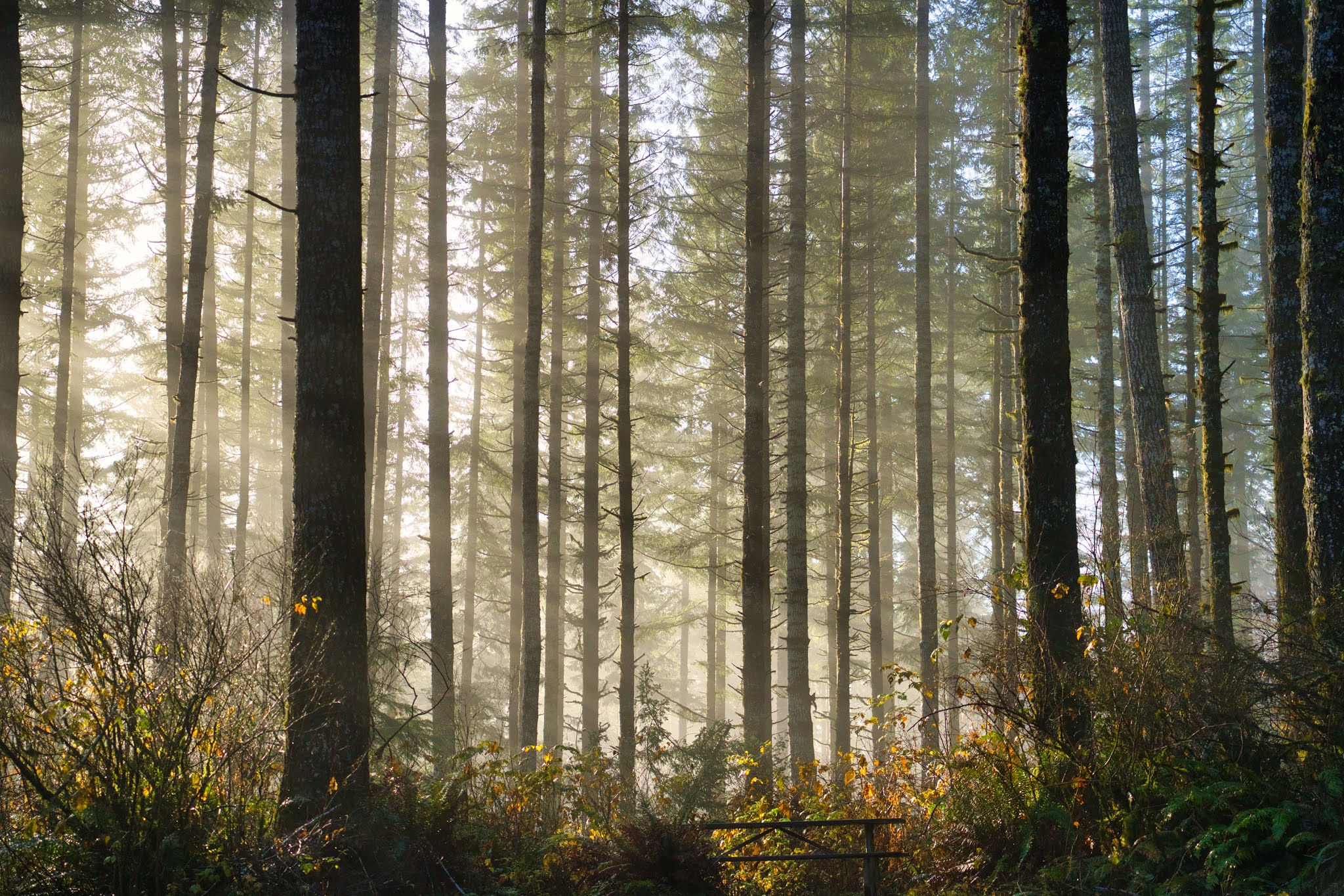
When we got to the parking lot, we were the third car there. The early November morning in the mountain forest was chilly and we could see the sun rays peeking through the fog. It was a beautiful site. Since it was Black Friday, no fee was needed to use the trail.


The hiking trail went downwards unlike many other trails. The trail itself was quite muddy and slippery due to the moistures in the air, but the air was extremely fresh. The trail then went around the creek and went across the creek on a wooden bridge. Once we crossed the wooden bridge, we were almost at the falls because we could hear the loud water running sound.


After about 5 minutes, we reached the suspension bridge. This suspension bridge was long and narrow. The bridge pretty much only allowed one person to go through at once. That was how narrow it was. The surface of the bridge was a bit icy and slippery. Thus we were being very careful and walking slowly to make sure we did not slip.


From the top of the bridge. we could see the falls from above. The amount of water running through the creek was breathtaking.


We then crossed the suspension bridge and headed downwards to the river side. From here we could see the falls from the bottom and also see the suspension bridge right above us. The water was icy cold!


As we depart, more people were hiking on the trail and there were cute dogs too! When we got back to the parking lot, it was already full and it was only about 10:30AM. It was a fun little hike in the morning and a nice walk outside during the weekend.

Sunday, November 1, 2020

Fort to Sea Trail

Tags


Fort to Sea Trail is a somewhat unpopular trail near the Northwest Oregon Coast. The hiking trail is about 6 miles long, so the round trip distance is 12 miles. The trail head is about 5 miles North of Seaside and people can either start the trail from the "Sea" or from the "Fort". The Fort that is referred to here is the Clatsop Fort that is built back in 1800 when Lewis and Clark ventured to the West. The trail is not as popular due to its length.


On this beautiful sunny October weekend, we decided to give this a try. We drove about 1.5 hours to get to the trail head at the "Sea" because we wanted to come back to the beach and relax there. When we got to the trail head, we saw 2 cars in front of. 1 car parked and the people in the car hopped into the other car. We were thinking that they must be heading to the Fort and just do a one way hike, which is quite a smart move.


The day was quite sunny. The first part of the trail was 2 miles towards Highway 101. The trail went through prairie land covered with tall grass. Then the trail went on a beautiful white bridge to cross Sunset Lake. The bridge was beautiful. We think it was a great spot for taking wedding photos. After the bridge, the trail cut through several cow farms.

These cow farms were so green with just few cows on it. Although it was quite smelly, we still enjoyed hiking through the farm. The trail was zig zagging through the farm and went through wooden gates to hop from 1 farm to another. Make sure you don't get lost when looking for the trail because we were quite confused on how to proceed when we hit the first wooden gate.


After going through the tunnel under Highway 101, we were starting to head upwards to Fort Clatsop. On the side of the trail, there was a farm with electrical fence, so make sure you don't touch it. There were also few snakes wondering around on the trail. We almost stepped on one of them.


The trail started to climb for the next 1.5 miles. The elevation gain was minimal but still made us to sweat. After about 30 minutes. We got to the top of the hill at the outlook. The view from here was kind of blocked by trees. So it was not the spectacular. The view point was a let down, but we were excited that we were close to Fort Clatsop.


From the outlook to Fort Clatsop was only 1.5 miles with down hill trail. We were walking quite fast and got to the Fort in 20 minutes. There weren't many people there. Due to the pandemic, the side entrance to the Fort was closed. Thus we went through the visitor center to get to the fort. Fort Clatsop was quite small and very well maintained. The bit room with the fireplace on the right was for the captain and the rooms on the left were for the others. It looked like the captain had a lot of privilege. There were also few other trails in this area along the river side and the canoe landing.


After paying a visit to Fort Clatsop, we were ready to head back to the "Sea". Heading back down to the coast was much faster and we got back within 2 hours. Along the way we also saw 2 people covered with white blankets as ghost along the trail because it was Halloween!

From the parking lot to the beach was just about 0.5 miles. The Sunset Beach was beautiful, especially with the sun setting on the West side. We saw many cars drove on the beach and people having picnic right on the sand. It was such as relaxing moment to enjoy.


The Fort to Sea trail was definitely better than what we expected. It was an easy trail with lot of change in scenery along the trail. We enjoyed it quite a lot. 12 miles round trip may sound a lot of this type of trail, but it was definitely worth the effort. If 12 miles is too long, people could always turn back after hitting Highway 101.

Sunday, October 25, 2020

Cape Meares

Tags


Cape Meares is located East of Portland on Oregon Coast near Tillamook. From Portland, it takes approximately 2 hours of drive time to get there. Cape Meares is a National Wildlife Refuge area with few easy hiking trails. At the top of Cape Meares, there is also a light house located right above the cliff near the coast line. Most of Cape Meares trails are quite easy and short. Thus the parking area is not that big because people tend to just come and go. For day use, there are few picnic tables around for people to enjoy the nature.


We drove to Cape Meares since we were visiting Tillamook Creamery that day. When we got to Cape Meares, there was not too many people. The parking lot at the top was essentially empty. From the parking lot, there was a trail the directly leads people to the light house. The trail was well paved and thus it was suitable for people with all ages.


There were few look out points along the trail with binoculars. People could use the binoculars to spot sea gulls and seals along the rocks on the coast. If you were lucky, you could also spot whales migrating along the coast.


The light house at the end of the trail was not tall. It had red coloured glass around its light. It would be a pretty sight if we came here at night to see it light up. Unfortunately, we could not enter the light house to look at it more closely either. At the bottom of the lighthouse, it seemed like there was a small gift shop there. But due to the pandemic, the gift shop is temporarily closed to avoid having crowd.


The lighthouse trail was a loop that goes all the way back to the parking lot. The trail went around the lighthouse and went along the cliff side of Cape Meares. From this side, we could see the entire Oregon coast beneath us. We could see the waves crushing towards the Oregon beach and the rain cloud was also just moving in quickly.

Overall, it was a fun trip to head out for a nice nature walk during the pandemic. We would definitely be interested to come back again to check out the inside of the lighthouse when it reopens in the future.

Sunday, September 20, 2020

Bottle Rocket

Tags


Bottle Rocket is a popular food cart located at Hawthorne Food Cart in East Portland. It serves mainly burgers with unique side and also serves homemade lemonade and various kind of beers that are brewed locally. Hawthorne Food Cart has been a popular food cart location for people in Portland and Bottle Rocket is one of the most popular choice there.


We went to Hawthorne Food Cart on Sunday to catch up with friends visiting from California. They have heard of the food cart culture in Portland and thus wanted to try as many food cart as possible. We chose Hawthorne Food Cart since it is closer and also offers good food cart experience.


Bottle Rocket is located on the East side of Hawthorne Food Cart area and the food menu includes hamburger, cheese burger, and bacon cheese burger. The sides includes various vegetable choices. People can choose to make a meal that includes the burger, a size, and a cup of homemade lemonade.


We ordered a Bacon Cheese Burger meal with Tempura Cauliflower as the side. After we placed the order, we also realized that we can choose to have bigger, or smaller burger. We chose the bigger one of course.

The burger is being cooked after the order is placed, but it was served quite fast within 10 minutes. The burger came with a large thick beef petty, which was quite juicy. There were also lettuce, onion, and pickled vegetables in the burger which provide amazing taste. A small portion of barbecue sauce was also give on the side if we wish to add more sauce in the burger.


The side was served in a Chinese takeout paper box. We were not expecting that. We chose the Tempura Cauliflower, but it was more like fried mixed vegetable. On top of cauliflower, there were also onion and jalapeno in there. There was a limited amount of cauliflower served in the box, which was a bit disappointing.


The homemade lemonade was not bad and quite refreshing.


Overall, Bottle Rocket serves great burger that's juicy and full of flavors. However, the side we chose did not meet our expectation and we would definitely try a different side next time. In addition, our friends ordered the beer from there and they loved it.

Sunday, September 6, 2020

South Sisters Summit 2020

Tags


South Sisters Summit trail is one of the most popular hiking trail at Central Oregon. South Sisters is the third tallest mountain in Oregon and there is a way to head to the top of the mountain. Every summer, thousands of hiking enthusiasts come here to do camping, day hikes, and night hikes. This hiking trail is especially crowded during the weekend. The hiking trail is about 40 minutes West from Bend and about 4 hours away from Portland. The trail is about 6 miles 1 way starting from Devil's Lake and the elevation gain is nearly 5000ft.


During the Labour Day long weekend, we decided to take Friday off and do a night hike on Thursday night since the weather is warm with low wind. We left Portland right after work and got to the trail head by 11PM. We decided to rest a bit after a long drive, thus we started the hike at 12:30AM.


When we started hiking in the first section of the trail in the forest, it was so warm and humid. We took off our jacket and outer layer to cool off. The night had a full moon in the clear sky, we barely needed to have our head lamp. The full moon was almost bright enough for us to see the trail ahead.


As we make our progress on the trail, we heard some tree branch dropping sound on the side of trail. We were alerted by this and used flash light to look around. We did not see any movement however, but suspected that there were animals around us. We stayed quite cautious as we proceeded further but did not see anything.


As we headed out of the forest, we saw a pair of shining eyes right in front of us about 15 feet away. The pair of eyes disappeared very quickly but we could clearly see our head lamp light reflecting off the eyes. We were being very careful and worried if it could be some vicious animal. For the next 10 minutes of hike, we maintained alerted status to ensure no surprises could jump at us.


After we crossed the plan and got to the rocky area, we ran into a man sleeping in a sleeping bag right on the side of the trail. Apparently we woke him up and he said he was just taking a rest. The rocky section was tiring to hike on because we had to pay close attention to where the trail was so that we would not get lost. By the time we got to Tear Drop Lake, it was around 4:30. We were hiking quite slowly compared to before.


We took a 30 minutes reset and started to make final ascend. The final part of the trail is the most difficult part. It was sandy and sipper, and the incline angle is like 60 degree. It would have been better with hiking poles but we did not carry any. It took us nearly 2 hours to complete the last part to get to the summit, but it was totally worth it.


The summit was windy but beautiful. We crossed the snow field to climb to the summit and we could see North Sister and Middle Sister. The sun rise was beautiful. It made the whole hike worth it.


Overall, this was a great hike. We do it almost every year as we enjoy this outdoor area very much. We highly recommend this hike but do prepare to carry enough water to stay hydrated.


Sunday, August 16, 2020

McNiel Point

Tags


McNiel Point is a quite popular hiking trail within Mount Hood National Forest. The trail goes through variety of terrains including great view of Mount Hood, the view over Mount Hood Forest, and the wildflower meadows. The trail is about 10 miles long round trip with about 2000 feet elevation gain. Thus the trail itself is not really difficult. The trail head is at Top Spur, which can be reached by going through LoLo Bypass Road. The parking space at the trailhead is limited however, but people usually park on the side of the road.


On this super hot day in Oregon, we decided to get somewhere high in the mountain to cool ourselves down. We got to the trail head around 8:30AM. It took us about 1.5 hours to get here. When we got there, the parking lot was already full and we had to park on the side of the road. The trail also requires Northwest Pass. When we were there, there were several groups of people carrying camping gears to do the Timberline trail.


As we started our hike and reached an intersection with 3 trails leading to different direction. The notice board has a map and requires every hiking group to fill out the safety form. We then took the trail #600 on the left.

The first portion of the trail is to go through the forest. This part is about 1.5 miles long with some elevation gain. The trail itself was quite wide with a couple of bugs flying around of course. After 1.5 miles, we got out to the lookup point which has a great view of Mount Hood. We had a quick little rest and reapplied the bug spread before heading further.


After about another 1.5 miles, we got to the meadows where all the beautiful wildflowers were. The wildflowers were simply just on the side of the trail and was beautiful. Some part of the trail requires people to go across streams of water, but it wasn't a big deal for us.

After about 4 miles of hike, we got to the rocky area where we had to climb over rocks on the side of the cliff. This part may sound and seem scary, but it was very easy to get through. We saw a guy trying to climb this with his hiking pole, and he was having a lot of difficulties. So the advice is not to use hiking pole here.


After 2.5 hours, we got to McNiel Point, which is at the shelter made out of rocks. The view from the top over the Mount Hood National Forest was breath taking. We could see mountains on the far side and the river running below. While we enjoy some food at the top, there were several dogs running by as well and asking for food. These dogs were quite energetic.

As we headed back down, we ran into a group of people with a Black Labrador Retriever. The Black Lab suddenly sat down in the middle of trail and she seemed exhausted.

Overall, this trail is one of the most amazing trail. We would definitely come again and next time we could try to do a night hike to see the sunrise from there.

Sunday, August 9, 2020

Skyline Trail

Tags


Skyline Trail is located at Paradise within Mount Rainier National Park. It is located at the South side of Mount Rainier and it is one of the most popular trail within the park due to its panoramic view of the mountains. Skyline Trail is a loop that goes up along the ridge of Mount Rainier and loops back to Paradise. It has a total distance of about 5.5 miles with some elevation gain. It also goes by the Myrtel Falls.


We left Portland early in the morning around 5:30AM and got to Paradise around 8:30AM. The parking lot at Paradise was nearly full at this time. We were shocked at the amount of people there. We didn't know the trail and Mount Rainier National Park is so popular.

Unfortunately, the weather was not so good on this day. It was extremely foggy with visibility of about 10 meters and has a lot of mist in the air. We couldn't even see the mountains.


We started the Skyline Trail hike around 9AM. Instead of heading to Myrtel Falls first, we headed the other way towards West first. The trail started to climb right away but it was not difficult at all. The first part of the trail was even paved and very easy to walk on.

When we went past the intersection that heads to the glacier lookout, the trail was covered by thick snow. The snow on the trail has not completely melted yet. Thus we walked on top of the snow field to cross to the next section of the trail. The rest of the trail was quite easy to follow with signs and we got to panorama point by 10:30AM.


At the panorama point, it was so foggy and misty. We couldn't see anything at all. There was so much mist in the air and our hair were wet. Since we just climbed up to panorama point, our body was still warm, thus we took the rest to have some food. While we were up there, we were surprised that there was toilet here a panorama point.

We continued on Skyline Trail after having rested at panorama point. The next section of the trail was beautiful. There was a variety of wildflowers blooming along the mountain side with different colours. We have never seen so many wildflowers bloom at once with different colors. It would have been an amazing sight if it wasn't so foggy.
While we were heading down the Skyline Trail on the East side, there were more sections of the trail covered with large pile of snow. Some part of the snow covered trail was slippery and we had to slide down due to the steepness of it, but it was quite fun. We enjoyed it quite a lot. We also had to cross a rushing stream of water and make sure our feet did not soak in the water.

We got back down to Paradise by 12:30PM. It was a great experiencing doing the Skyline Trail. The fog was clearing a bit but not complete. We still could not see the top of the mountain.

While we were driving back down the mountain, we also saw a Blacktail Deer along the side of the road. We were surprised that he was not afraid of the cars.

This was our first time visiting Mount Rainier National Park and it was much closer to us than we thought. We would definitely come here more often in the future.

Monday, July 20, 2020

Crater Lake 2020

Tags

Crater Lake is the only National Park in Oregon and the lake is known to be the purest and deepest lake in US. The water in Crater Lake is so pure because there is no inlet or outlet to the lake. All the water came from the rain and the melted snow from the winter. The Crater Lake National Park itself is not very large and it mostly covers the surrounding area of the lake. The drive time from Portland to Crater Lake is about 4.5 hours. During the winter season, majority of the road is closed at the National Park and only the road to Crater Lake Lodge is still accessible.


We were lucky to be able to make 2 nights reservation at Crater Lake Lodge. We left early on Friday morning around 6:30 AM and got to Crater Lake National Park around 11AM. We first stopped by Watchmans Peak to have an awesome view of Crater Lake. On Crater Lake National Park website, it indicated that the trail has been closed due to lingering snow, but we still did it any way and it was well worth it!


We then drove to Rim Village to check out the gift shop. However, the wait line at the gift ship was so long that we gave up. Thus we went driving along East Rim drive and went to Mount Scott. The Mount Scott Trail is another popular trail. We love to view things from the top, thus this was a must do for us to see Crater Lake from the top!

After coming back down from the mountain, we drove back to Crater Lake Lodge to check in. We got the room on the first floor. The furnace in the room was so noisy and we were unable to turn it off. That was a bummer.


At night, we drove to the East side of Crater Lake to find a good spot to view NEOWISE comet. We somehow spot a place where everyone was at and that turned out to be the best spot to view comet. We got to Pumic Castle view point where everyone was taking photos. The NEOWISE comet under the Big Dipper was amazing. We could even see the reflection of stars on the surface of the lake! Then we turned around and also saw extremely clear Milkyway right above us on the East side.

On the second day, we woke up early at 5AM to see the sunrise from Rim Village. It was so amazing. Then we went to climb Garfield Peak to have a panoramic view over the entire Crater Lake National Park.


We then drove towards West Rim drive and visited all the view points. Eventually we got to the North of Crater Lake and took Cleetwood Cove Trail to get down to the shore of Crater Lake. It felt good to feel the water of the purest lake in US.

At night, we went to Watchman Peak viewpoint again just to see the Milkyway. The Milkyway was right above the lake. The view was breathtaking! While we were taking photos, we saw a group of people there having hot pot. We were so shocked. Then the park ranger came and ask them to pack up the food so that bears don't get attracted. The park ranger also asked whether we heard of any firework due to some firework report to the rangers.


When we headed back Crater Lake Lodge, as we parked the car, a deer was right in front of us! That was a crazy surprise. As we got out of the car, the deer zoomed by us so fast and we were stunned!

Overall, this was a lovely trip to Crater Lake. Crater Lake was still so beautiful and pure with deep blue colour. We would definitely visit this place again!

Cleetwood Cove Trail

Tags

Cleetwood Cove trail is the only trail that goes down to the shore of Crater Lake, and thus it is also the most popular trail within Crater Lake National Park. The Cleetwood Cove trail is located on the North side of Crater Lake. It is about 2.2 miles round trip with decent elevation gain. This trail typically gives hikers a work out when coming back up. This trail is also a must do if you want to go on a boat tour or go to Wizard Island because the boarding point is at the bottom of the trail.


We got to the trailhead around 11AM in the morning and there were not that many cars there. We also noticed that the parking lot has been expanded since 5 years ago to accommodate twice as many cars. Since there was not boat tour service during the pandemic time, the rest room at the cove was also closed, but this did not stop people from going down to enjoy the Crater Lake water.

The trail descends at a constant pace. We could see the lake on the side all the time as we hike down. One thing good about this trail is that it is covered by shades due to all the large trees on the side. This helped to keep our body cool and not exposed to the glaring sun.


As we hiked down, we saw a girl fell and crying. We felt really sorry but there was a nice guy providing first aid kit to bandaid the girl's wound.

We finally got to the bottom after 30 minutes and there were already so many people there enjoying the fun in the water. People were jumping off the cliff into the water and swimming. There were also people fishing there but just have to keep in mind to only use artificial lures.

We climbed down to get close to the water and the water was not as cold as we thought. We took off our shoes and dipped our feet in it. It felt so good. We stared right down into the water and it was so blue. The colour of the water was so blue that it was kind of scary. It was hard to tell how deep it really was.


After about an hour enjoy the water, we headed back up the trail. Climbing back up was more difficult with constant climb. However, we actually climbed back to the top without taking a rest in between.

This is definitely a must visit place when visiting Crater Lake. This is the only place to get your hands into the water and feel how pure the water really is.

Garfield Peak Trail

Tags

Garfield Peak trail is one of the most popular trail located within Crater Lake National Park. The trail is only 3.4 miles roundtrip and the trailhead is right beside Crater Lake Lodge. Thus the trial itself is very accessible to visitors. The trail has some elevation gains but not difficult. However, for some reason, the trail is marked as strenuous. Most people do this hike in the early morning to see the beautiful sun rise over Crater Lake.


We woke up early in the morning around 6AM to do this trail. The early morning air was chill but was not as cold as we thought. As we walked towards the trailhead, we were joined by few other groups of people. Some hikers were alone by themselves and we figured that their family might still be sleeping.

The trail was not difficult at all. The climb was gradual and the trail itself was quite wide. The view along the trail was simply breathtaking. We spent so much time stopping by every viewpoints to take beautiful photos of Crater Lake.


As we hiked up, we also ran into a groundhog! The groundhog was quite chubby with a huge tail at its back. It was right in the middle of the trail staring at us for almost a minute before it ran off to the side. It was hilarious.

We got to the top after about 40 minutes of hiking. When we got up, no one was there and we figured it was because we spent too much time taking photos along the way. The top of the mountain has a large platform for people to rest. It also has a panoramic view over Crater Lake National Park. We could just see how round Crater Lake really is.

When we hiked back down, we started to see more and more people coming up. We really recommend to do this trail and preferably in the morning. The sun light that shine on the surface of Crater Lake was just so amazing.

Sunday, July 19, 2020

Mount Scott

Tags

Mount Scott is the highest point within Crater Lake National Park in Oregon. Its peak has an altitude of 2723m and overlooks Crater Lake. The Mount Scott trail is located on the West side of Crater Lake. The trail itself is about 5 miles roundtrip with about 1000ft in elevation gain. Thus the trail itself is not difficult and quite popular among the visitors to Crater Lake National Park.


We go to Mount Scott trail head by around 1PM in the afternoon. There was about 10 cars parked there. The trail started quite flight through the prairie and the climb started short after. When we were there, the sun was very glaring and hot. However, whenever we go under the shade, the breeze felt really good, just like an AC.

As we make our climb, we also encountered many people coming back down. We were counting the group of people we see and figured that we were probably the last group of hikers on this trail.


After about an hour, we reached to the top of the ridge and we could see the hut at the far end of the ridge. The ridge of Mount Scott has a panoramic view on both sides. We could see Klamath Lake to the Southeast. The view was magnificent.

When we got to the hut, we found the area for sitting down was quite limited. There were many large rocks near the edge of the cliff. There were also bad odor coming from the side of the hut and we figured that someone probably peed here.


Nevertheless, the view over Crater Lake was just amazing. We enjoyed our time up there with cold breeze under a hot sunny day.

Overall, this is an amazing trail for people to do. This trail may be difficult for some people who do not hike on regular basis, but we still strongly recommend this trail. In addition, this trail was not busy at all on the Friday afternoon, but the parking lot was packed full when we drove by on Saturday.

Watchman Peak Trail

Tags

Watchman Peak Trail is a popular trail with lot of traffic. The trail is located on the West side of Crater Lake with beautiful view point at the trail head. This is also one of the only trail with restroom at the trailhead. The trail itself is only 1.6 miles roundtrip with some elevation gain. Thus it is very family friendly and suitable for people with all ages.


We got to the trailhead around 10AM and there were still parking spot. When we got there, the trail was marked as closed due to lingering snow. However, when we hiked up a bit, we only see a very tiny section of trail covered in snow with nearly no risk of slipping. Thus continued to hike the trail like many other people.

The trail continuously climb upwards with consistent elevation gain. We saw many people wearing masks on the trail due to the pandemic.  As we hiked further, we got to the intersection where the right side goes to Rim trail and left side goes to Watchman Peak. We continued on to Watchman Peak and got to the top within 30 minutes.


At the top Watchman Peak, the breeze of the wind felt so good. There was a hut at the top for rangers to overlook the entire Crater Lake National Park. At the time when were were there, there were no rangers stationed there.

From the Watchman Peak, we could see the entire Crater Lake. The view was simply amazing. We could see how round Crater Lake really is.  The Wizard Island was just in front of us as well and we could see the crater at the top of Wizard Island.


When we came back here at night, we could also see people doing night hike to the top of Watchman Peak. The top of the peak offers a magnificent view of Milkyway.

Overall, Watchman Peak trail is a must do trail when visiting Crater Lake. It is quite an easy trail and offers one of the best view over Crater Lake.

Saturday, July 4, 2020

Boca Cave

Tags

Boca Cave is a large naturally formed cave near Detroit, Oregon. The cave faces Mount Jefferson, and thus the cave forms a perfect frame for Mount Jefferson. For people doing the Triangulation Peak trail hike, Boca Cave is a must visit place since it is just near by. The trail is only about 0.2 miles further off the main Triangulation trail.


We did the Triangulation Peak trail and enjoyed the view very much from the top. We then headed to look for the trail that leads to Boca Cave. However, it was not easy to find. We then came across a place where 2 people camped there and they told us that the way to Boca Cave is through here. Apparently their camp ground blocked our view of the trail. We were thinking that this would be a good strategy in ancient warfare, where the army could make settlement at the middle of the major intersection.


We went forward through the camp site and still had difficulty following the trail. We looked around to find any sign of the trail and then realized that there is a "CAVE" sign with an arrow made out of rocks. We were laughing so hard and feel grateful to people who created this sign. The trail leads to the bottom of the mountain and so we went. Then we lost the trail again because there seems to have been forest fire in this area. All the trees were burnt and thus tracking the trail became a bit more difficult.

Since we kind of knew where the cave should be by looking at the map on the phone and also knew that the cave must face Mount Jefferson, we eventually made our way down and got back on track onto the trail. The trail heading to the cave was a little steep heading down and slippery close to the cave due to all the water flowing through.


The cave was larger than what we expected. Since we were the only one in the cave ,we were making weird voices to hear the sound echoing within the cave. It was quite fun. The view of Mount Jefferson was also awesome of course.

On the way back, it was easy and did not have to follow the trail because we know we have to climb back up to the top of the cliff.

Overall, this was an amazing experience and highly recommend visiting Boca Cave. The only caution here is to take slower pace heading to the cave to avoid tripping over on slipper surface.

Triangulation Peak

Tags

Triangulation Peak is located near Detroit, Oregon. It is a well known location to have a perfect view of Mount Jefferson. However, this trail is not as popular as many other trails due to being further South and takes about 2.5 hours to get to from Portland. The trail of Triangulation Peak is about 2.5 miles with little elevation gain. The only climb is only at the last 0.5 mile of the trail.


We left Portland around 7AM in the morning to drive to the trail head. Before we get to the trail head, we drove by Detroit Lake and the camp grounds were complete full. So despite of uprising of COVID-19 outbreak, it did not stop people to enjoy the July long weeend.

After driving by Detroit Lake, we made a left turn into the Forest Road. The first 5 miles of the Forest Road is well paved. The road is a bit narrow but not really a problem for 2 cars to pass by each other. The next 3 miles of the road is on gravel road. The gravel road is well maintained however.


We got to the trail head by 9:30AM in the morning. There were already 4 cars there and the parking space was limited. We were early so able to get a parking space ourselves. The trail itself was narrow but not difficult. However, there was a lot of uproot branches which could trip people over. There were also many bugs flying around in the morning with high moisture in the air.

After about 40 minutes, we got to an intersection. The trail on the right is to the peak and the left path goes further into the mountain. We took the right path and the trail started to climb gradually. After about 15 minutes, we got to the top of Triangulation Peak. From the peak, the view of Mount Jefferson was magnificent. We could also see Broken Top on the very far side. The forest down below also look so tiny and the breeze at the peak just made the morning feel so awesome!

By the time we got back down to the trail head, there was a lot more people coming in. There was not enough parking space for everyone and thus people had to park on the side of the road. Thus it is recommended to come early if possible.

Sunday, June 28, 2020

Trillium Lake 2020

Tags

Trillium Lake is one of the most popular lake within Mount Hood National Forest. It is not as big as Lost Lake, but still a very popular place for people to enjoy lakeside activities. Trillium Lake also offers a large number of camp sites and day use picnic area for people to enjoy. It is also a popular destination for fishing lovers. Trillium Lake is about 1.5 hours East of Portland, and thus it gets quite crowded during the summer weekend.


We got to Trillium Lake around 9:30 in the morning and the parking lot was not full yet. Like many hiking trails, Trillium Lake requires day use fee or people like us usually acquire Northwest Forest Pass for the whole year.

The hiking trail around Trillium Lake shore is around 2 miles. There are well maintained board walks along the trail so it's suitable for people with all ages. We also saw a small amphitheater along the trail.  As we hiked about 1 mile, we got to a place with a sign indicating the trail ahead has temporarily closed due to lack of maintenance. We did not go forward as we did not want to risk for any injuries.


We then went the opposite direction and saw many people fishing along the shore. Quite a few people caught buckets of fish. Many people were also kayaking and paddle boarding  on the lake.

We also saw many Golden Retrievers enjoying their time running around and swimming in the lake. They are lovely dogs. However, the dog that got most attention is a Bernese Mountain Dog puppy. He was a fluffy chubby puppy. Everyone loved the adorable dog.

As we were leaving at around 11AM, the parking lot was full and many cars simply parked along the side of the road. We also started seeing Labrador Retrievers coming to the lake to enjoy the sunny weather. Trillium Lake has always been our favourite place to visit during the sunny weekend where we just want to relax and not to do any crazy hike. We definitely recommend it for any fun family gathering.

Monday, June 22, 2020

Tamanawas Falls

Tags

Tamanawas Falls is located on the East side of National Mount Hood Forest. The hiking trail to this waterfall is often crowded during the summer weekends. The trail is right off the Highway 35 with about 40 parking spaces. The trail is 2 miles long with very little elevation gain. There is also a restroom facility at the trail head for people to use. In addition, as usual, Northwest Pass or equivalent is required to use this trail.


We left Portland around 6:30 in the morning and got to Tamanawas Falls trail head around 8:30. It took about 2 hours to drive to there. When we got there at 8:30 in the morning, there were only 5 cars parked there.

The hiking trail is on soft soil but with a lot of large rocks that we need to step on. Many of these rocks have very smooth surface and can be very slippery, especially near the waterfalls.


Along the trail, we crossed 2 narrow bridges to cross the river. The bridge was very narrow and only allows 1 person to walk through at a time. Since it was not crowded when we went, we did not have to wait for anyone to cross first.

The only elevation gain we encountered is near the very end where we have to climb over this large rocky cliff. This part of the trail was not difficult. However, as mentioned before, some rock surface is quite smooth and slipper. Thus extra caution is advised.

We got to Tamanawas Falls around 10AM. We were overwhelmed by the volume of water coming out of this waterfalls. It was crazy. We were sitting quite far away and could still feel the mist flying over onto our faces. It was a beautiful scenery nonetheless.

While we were there, we saw left over nut shells on the ground and were quite disappointed at people who simply throws away wastes. People should never do that.


As we walk back around 11, we started to see a lot more people on the trail and started to get quite crowded. On the way back, we also saw a tiny little snake on the trail that ran down the hiking trail. Then at the narrow bridge, we actually had to wait to use the narrow bridge because people wanted to take some photos on the bridge.

Furthermore, due to the corona virus outbreak, there were people wearing mask on the hiking trail and people stand far from each other on the trail.

Overall, this was a nice easy hike for family of all ages. We definitely recommend this hiking trail, but make sure to come as early as possible.