Fort to Sea Trail is a somewhat unpopular trail near the Northwest Oregon Coast. The hiking trail is about 6 miles long, so the round trip distance is 12 miles. The trail head is about 5 miles North of Seaside and people can either start the trail from the "Sea" or from the "Fort". The Fort that is referred to here is the Clatsop Fort that is built back in 1800 when Lewis and Clark ventured to the West. The trail is not as popular due to its length.
On this beautiful sunny October weekend, we decided to give this a try. We drove about 1.5 hours to get to the trail head at the "Sea" because we wanted to come back to the beach and relax there. When we got to the trail head, we saw 2 cars in front of. 1 car parked and the people in the car hopped into the other car. We were thinking that they must be heading to the Fort and just do a one way hike, which is quite a smart move.
These cow farms were so green with just few cows on it. Although it was quite smelly, we still enjoyed hiking through the farm. The trail was zig zagging through the farm and went through wooden gates to hop from 1 farm to another. Make sure you don't get lost when looking for the trail because we were quite confused on how to proceed when we hit the first wooden gate.
After going through the tunnel under Highway 101, we were starting to head upwards to Fort Clatsop. On the side of the trail, there was a farm with electrical fence, so make sure you don't touch it. There were also few snakes wondering around on the trail. We almost stepped on one of them.
The trail started to climb for the next 1.5 miles. The elevation gain was minimal but still made us to sweat. After about 30 minutes. We got to the top of the hill at the outlook. The view from here was kind of blocked by trees. So it was not the spectacular. The view point was a let down, but we were excited that we were close to Fort Clatsop.
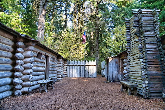
From the outlook to Fort Clatsop was only 1.5 miles with down hill trail. We were walking quite fast and got to the Fort in 20 minutes. There weren't many people there. Due to the pandemic, the side entrance to the Fort was closed. Thus we went through the visitor center to get to the fort. Fort Clatsop was quite small and very well maintained. The bit room with the fireplace on the right was for the captain and the rooms on the left were for the others. It looked like the captain had a lot of privilege. There were also few other trails in this area along the river side and the canoe landing.
From the parking lot to the beach was just about 0.5 miles. The Sunset Beach was beautiful, especially with the sun setting on the West side. We saw many cars drove on the beach and people having picnic right on the sand. It was such as relaxing moment to enjoy.
The Fort to Sea trail was definitely better than what we expected. It was an easy trail with lot of change in scenery along the trail. We enjoyed it quite a lot. 12 miles round trip may sound a lot of this type of trail, but it was definitely worth the effort. If 12 miles is too long, people could always turn back after hitting Highway 101.


EmoticonEmoticon