Friday, June 11, 2021

Peekaboo Trail


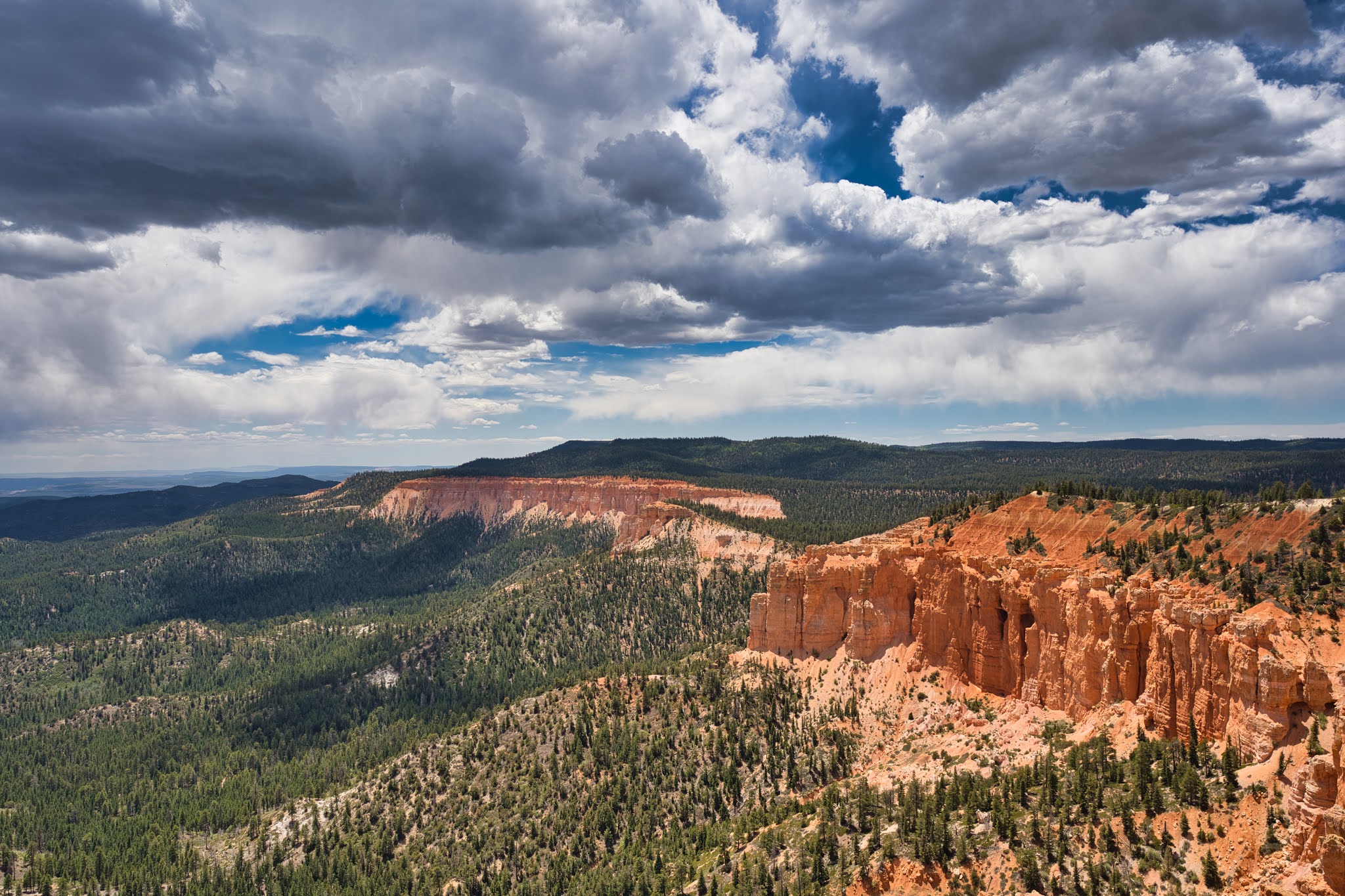
Peekaboo Trail is another popular trail within Bryce National Park. The trail itself is a loop and 3 miles long. It is located at the bottom of Bryce Canyon and loops around the magnificent Bryce Hoodoos. It is recommend to visitors to do Peekaboo Trail along with the Navajo Trail since there are rather close to each other. In addition, when hiking Peekaboo Trail, it is recommended to do this in clockwise direction to ease the hike.


We did Peekaboo Trail while we were hiking the Navajo Loop Trail. As the guide suggested, we started the trail with clockwise direction. The beginning of the trail was less interesting in a forest like section. However, the trail became rather beautiful with Hoodoos and colour rock formation along the trail.


The trail itself has some elevation gains but not too big of a deal. From many different part of the trail, we were having amazing views over the Bryce Canyon. It was so beautiful. We couldn't stop from taking more and more pictures.


When we were about 1 mile in, we were at an intersection with another trail that connects to Bryce Point. Some people chose to come down here from Bryce Point. This part of the trail was sand and rock formation and quite unique. The scene was really something from World of Warcraft. The trail was flat and goes around red rock canyon with few pine tress growing in between.


As we past the 1.5 miles mark, we saw the Windows. These were 2 windows high up on the cliff side. These Windows were just like the arches that you would see at Arches National Park. Other than the Windows, there were even more Hoodoos along the side.


Along the trails, there were also many tunnels that led the trail to go through the rocks. Some of these tunnels can be quite long and some were short where we had to bend over to pass through.


While we were hiking, we also saw many individual hikers on the trail, which is something that we did not see very often. We were thinking that they could be collage students from near by Universities.


The last portion of the trail took us through the zigzag switchbacks to go upwards. Just like the Navajo Loop Trail, the switchbacks were well graded and it was quite a scenery. There were less people here and we were able to take many more pictures.


Overall, this was quite an amazing trail. We highly recommend to do this trail along with Navajo Loop trail, which sums up to be around 4 miles in total hiking distance.

Thursday, June 10, 2021

Bristlecone Loop Trail


Bristlecone Loop Trail is located at the end of the scenic drive in Bryce National Park. It is located at mile marker 18. The trail is quite short with only 1 mile in length but it does offer amazing view over the canyon. The trail starts at Rainbow Point Overlook. There is usually enough parking for visitors but sometimes it could get crowded.


We got to Rainbow Point around 1:30PM in the afternoon. When we got to the parking lot, the parking lot was already full. Fortunately the trail is short and people leave rather quickly. Thus we were able to find a parking space right away.


It was actually quite windy at the top of Rainbow Point since it is the highest point of Bryce National Park. Also, it was a bit cloudy so the temperature was not as high as we thought. We did bring additional layers of clothing just in case of such condition occurs.


The trail is a loop and the first section of the trail goes along the cliff side. This offers gorgeous view over the canyon with lot of colors to be seen. Along the trail, there were also many Bristlecone Pine Trees along the way and hence the name of the trail.


As we hiked down the trail, we noticed many burnt trees along the way. The ranger told us that these trees were burnt by them on purpose to reduce the risk of forest fire. It has been extremely dry this year with record low precipitation, thus the rangers want to reduce the forest fire risk.


We also saw few funny looking square box on the tree. We were wondering what it was used for. Then a ranger came by and told us that these boxes have motion sensors and they are used to count number of visitors each year. We never knew National Park Service does these type of things.


In general, Bristlecone Loop Trail is not as impressive as other trails in Bryce National Park. However, since all visitors at Bryce National Park will come to the highest point of the park, you might as well take a short hike around the trail.

Navajo Loop Trail


Navajo Loop Trail is one of the most popular hiking trail at Bryce National Park. The trail starts at Sunset Point within Bryce National Park and it is about 2 miles long. The trail takes you down into Bryce Canyon among all the Hoodoos. Navajo Loop Trail offer breathtaking view of the Bryce amphitheater and it is definitely a must do when visiting Bryce National Park.


We got to Sunset Point really early around 6:30AM, shortly after sunrise. The view was amazing under the early morning sun. It was simply incredible. As we head down to the trail, we were already spending so much time on taking lot of photos. Since the trail is a loop, we decided to go left first, which is the opposite direction of the Wall Street. This was because we wanted to see Thor's Hammer first.


After about 0.2 miles, we got to Thor's Hammer. Thor's Hammer is a strange looking rock standing by itself. The top of the rock looks like a hammer standing straight on the rock. The rising sun behind the hammer really gave an incredible view which made the look of the hammer even more divine. Many people were standing on the trail taking photos of this moment.


After a few moment, we got to a very interesting part of the trail. The trail was zigzagging down the hill between the rocky walls. This view was so fun and interesting. This scenery seems to be something from World of Warcraft. We really loved this little fun trail here. The trail was well graded and zigzagging downwards.


After getting down to the canyon, the trail loops back up on the East side.So instead of going down hill, it was time to climb back up. On this side of the trail, the trail goes through Wall Street. This section of the trail goes through a narrow path between really tall rocky walls. Some part of the path go right underneath the rock and around the boulders. It was really cool. This was definitely a different kind of feel compared to the hikes that we have done before. We enjoyed this very much to see the rocky wall formation.


Many people chose to take rest here because there is a lot of shade here. The tall rocky wall blocked the sun light. Interesting enough, there were still pine trees in this narrow canyon. The pine trees just kept on growing taller and taller. It was almost as tall as the wall.


We finished this trail in about 1.5 hours. Although it was only about 2 miles, we spent a lot of time taking photos. Otherwise we could have finished this trail under 1 hour. We highly recommend doing this trail when visiting Bryce National Park. It is definitely a must do on everyone to do list.

Oscars Cafe


Oscars Cafe is a Mexican restaurant located at Springdale, just right outside of Zion National Park. Oscars Cafe offers both indoor and patio seats to its customers and it is actually quite a large restaurant. Oscars Cafe is actually rated the most popular restaurant near Zion National Park and thus there is always a line waiting outside for available seats.


After a long day at Zion National Park, we put down our stuff at the hotel and walked around on the street of Springdale looking for a place for dinner. Initially we spotted Casa de Amigos Mexican Restaurant right across the street, but we did not see anyone there. Thus we were not sure if it is open or not.


We continued down the street and saw a line waiting in front of Oscars Cafe. Oscars Cafe was not facing the Main Street. We would have missed it if it wasn't due to the line waiting outside. We figured that we were going to get take out anyway so we decided to try Oscars Cafe.


We ordered a grill chicken taco salad and a chicken Enchiladas. It took about 20 minutes to get our food and we were already really hungry. The taco salad came with many ingredients, such as corn, carrot, mushroom, olive, tomato, avocado, and also 2 pieces of garlic bread. It was full of colour. The taco salad was quite fresh, even more fresh than what we have in Oregon! We enjoyed it very much.


The Enchiladas was amazing as well. It came with beans, rice, an Enchiladas, and a big jalapeño at the top. The whole thing was drizzled with this green spicy and sour sauce but the sauce was amazing. It was the right amount of spiciness and the sour taste just neutralized it. We really loved this.


We highly recommend to give Oscars Cafe a try when visiting Zion National Park. Although there may be a line outside, the wait is usually just around 25 minutes.

Wednesday, June 9, 2021

Zion National Park


Zion National Park is one of the most popular national parks in United States. It is located at Southwest corner of Utah state and has attracted thousands of visitors each year. It is known for its breathtaking canyon view and the hike in the Narrow. Currently, visitors are not allowed to drive their own vehicle into Zion Canyon and must take shuttle bus. The reservation ticket for shuttle bus is no longer required but still need to ride the shuttle bus into the park.


We planned to spend 1.5 days at Zion. We arrived at Springdale just outside of the park the night before. We had shuttle bus reservation ticket for tomorrow morning at 6AM. The hotel front desk told us we should be good to park our car at the visitor center parking lot since 6AM is still quite early.


The next morning we left the hotel at 5:30AM. As we approached the park, there were already so many cars on the road in front of us! Then we saw the road sigh indicating the parking lot was already full! We were shocked! However, we still drove to visitor center parking lot and found that there were still quite a lot of parking space. The sigh was quite misleading but we could imagine the parking lot to be full around 6:30AM.


We then went to the shuttle bus stop and it was crazy. The line waiting for the shuttle was extremely long. Since we have reservation ticket, we had the priority to board the shuttle. If we didn't have the reservation, we probably have to wait for another 2 hours before getting onto the bus.


The first thing we did was Angels Landing of course and that was where everyone else is coming. This is a must do hike when visiting Zion since it offers an amazing view over the canyon. As we come back down on the trail, we saw a long line up at the trail head with people waiting to do this climb.


We then took the bus and headed to the Narrows. The Narrows is a 9 miles long hike. The first mile is just on the river side and easy for people to hike. Then people must switch on gears to hike in the water and must hike with a stick to measure the depth of the water. We were not prepared for this and thus we did not do this hike unfortunately. However, we did see severals deers along the river side.


Then later in the afternoon, we took the shuttle bus to Zion Lodge and did hike on Emerald Pools Trail. This was an interesting trail with scenery of small water falls and pools of water that offers nice breeze of wind. However, we were pretty exhausted due to the excessive heat in the afternoon.


The next day we left hotel early at 6AM and drove to East Mesa. To get to East Mesa, we drove through the Zion Mountain Camel Highway. The view was quite scenic. Once we get to East Mesa, we did the Observation Point hike. This was a great hike that offers the same breathtaking view as Angels Landing. The view was simply amazing.


Overall, we enjoyed Zion very much and would definitely visit again next time. Next time we would definitely be prepared with gears to hike in the water and do the Narrows.

Zion Observation Point


Observation Point in Zion National Park is another amazing view point that offers the breathtaking view over Zion Canyon. The view matches the one that can be seen from the top of Angels Landing. However, getting to Observation Point is a bit tricky. People could have accused Observation Point via Weeping Rock trail head, but it has been closed due to falling rocks. Thus there are only 2 ways to get to Observation Point. The first method is via East Rim trail, but it is a 10 miles hike 1 way. 20 miles round trip may be too much for a lot of people. The second method is via East Mesa. From East Mesa trail head, it is only 3.5 miles and 7 miles round trip.


We did this hike early morning in the morning. We drove to East Mesa, which is on the East side of Zion via UT-9 Highway. Then we drove through Ponderosa neighborhood to get to the trail head. The last 0.5 miles of the road was quite rough. The road was poorly maintained. If you don't have a SUV, we recommend you to park the car before going down the rough road and hike the final 0.5 miles. We saw many people doing that.


The trail was quite easy to follow and the trail descends first. The climb is only on the way back. The trail to get to the Observation Point had little shade and was not interesting to be honest. It was essentially going through the woods with just few pine trees. There wasn't really any scenery to look at.


Luckily, the trail was very easy to hike on. We were walking at a very fast pace and got to the Observation Point in about an hour. When we got there, there was already a person sitting at the edge of the cliff looking down the canyon. The view was breathtaking, but we didn't dare to sit along the edge of the cliff. The vertical drop was quite steep!


From the Observation Point, we could see the top of Angels Landing as well. Observation point is much higher than Angels Landing and provides a better panoramic view around the entire Zion Canyon.


As we spend time there and enjoy the view, there were more people coming. There was a family of mom and daughter from Iowa coming over to chat with us to go over their hiking experience. They were passionate hikers too and plan to visit Oregon later this summer.


As we head back, more and more people were coming. People did seem exhausted since it was getting hotter in the day. Thus hiking this trail early in the morning is definitely recommended.


Overall, this was an amazing hike. The Observation Point provides an alternative to people who do not want to do Angels Landing and still offer the amazing view over Zion Canyon.

Emerald Pools Trail


Emerald Pools Trail is a short hiking trail in Zion National Park. It has a round trip distance of around 3 miles with little elevation gain. Thus it is very family friendly. The trail goes around the Lower Emerald Pool and Middle Emerald Pool. Then by hiking 0.5 miles more, you can reach the Upper Emerald Pool. The trail starts at Zion Lodge, which is the 5th stop of the Zion shuttle bus. Many people rest at Zion Lodge and then head over to Emerald Pools Trail.


We did this trail in the afternoon and it was scorching hot. It might have been a bad decision but we did carry enough water to keep ourselves hydrated. The start of the trail goes along the Virgin River and you could actually dip your feet in the river water. It was a blessing! Then the trail descends into a canyon wall where the Lower Emerald Pool is at.


Due to the low precipitation this year, there was barely any water dripping down from the top of the cliff. The pool of water was murky and at a very low level. However, as we walked around the pool, the breeze of the wind had never felt so good. It was a cold breeze and it was what we needed during this hot afternoon.


We then proceed and moved on to head to the Upper Emerald Pool. It was only 0.5 miles but it had never felt so difficult to hike this last 0.5 miles. The weather was extremely hot and we had to go between the narrow cliff wall and climb over some large rocks. We were pretty exhausted due to the heat.


As we finally made it to Upper Emerald Pool, the water level was very low at the pool. There was no water coming down from the top of the cliff either. It was about to get dry up. The good thing is that there was shade there and we could feel nice breeze around the pool.


In general, the trail was not as spectacular as other trails in Zion. People should only do this trail if there is extra time when visiting Zion National Park and make sure to carry enough water!

Tuesday, June 8, 2021

Angels Landing Trail


Angels Landing Trail is one of the most popular trail in the state of Utah. The trail is 5.5 miles long in round trip distance with significant elevation gain in the middle section and the last climbing section. Angels Landing is known for its magnificent view at the top and also known for its steep drop at the last 0.5 miles of the trail. The last 0.5 mile of the trail require hikers to utilize the chains that are installed along the cliff to hike up the rock.


Angels Landing is the very first trail that we attempted when we visited Zion. We got to the visitor center at 5:50AM and it was already so crowded. There were already so many people waiting at the bus stop and we were sure everyone was heading to the same place. Luckily we had reservation tickets at 6AM and thus we were allowed to get onto the bus before anyone else.


The bus stop for Angels Landing was at Grottos and as expected, everyone got off here. When we got to the trail head, the rangers stamped our hands which indicated that we were allowed to climb Angels Landing. The stamp was used to control the crowd going up there.

The beginning of the trail was quite easy with limited elevation gain. We were enjoying the view very much with between Zion canyon scenery. We loved it. After about 1 mile, the trail started to climb with switch backs. The switch backs were not difficult to hike on however, the trail was well maintained and nicely graded. We got to Scott's Lookout within an hour and it felt really good to be up here. From Scott's Lookout, the view was already so amazing. This was also the place for people to decide on whether to go forward to climb the chain, or stay down here and turn back.


One of us stayed behind to wait and the other went on to climb the chain. The chains were firmly installed along the cliff side for people to grab on. It was not a difficult climb, but anyone with fear of height should not attempt this. Part of the trail had a steep vertical drop right on the side and it could be very scary for people. Also, when there were people coming down while I was going up, I had to find a good spot to allow both of us to go through. After about 30 minutes, I finally made it to the top. The top of Angels Landing was a somewhat large surface of rock. People could rest here to enjoy the view and rehydrate. The view from the top was simply breath taking.


Going back down the chain section was a different challenge. This was because some sections require people to reach far down to set the footings on the rocks. Also, people would be starring down the vertical drop with the body leaning downwards.

After about 30 minutes, I finally made it back down to Scott's Lookout and there were already so many people there waiting to climb Angels Landing! When speaking to the rangers, people have to wait for an hour to get a chance to climb all the way to the top! It was crazy!


As we head back down to the trail head, there were just so many people flooding in to do this climb. We have never seen so many people on a hiking trail. It was insane! When we got to the trail head, there was a long line waiting at the trail head. We were told that the wait at the trail head was 2 hours! We were so glad that we started early.

Overall, Angels Landing trail was an amazing experience! If you have fear of height, do not attempt to climb the chain section! The views along the way are equally amazing! In addition, the West Rim trail was amazing as well! From the top of West Rim, it is higher than Angels Landing and you could see the entire canyon as well! Nevertheless, this trail is a must do when visiting Zion!