Sunday, April 18, 2021

Sevenmile Hill


Sevenmile Hill is located West of Dales, just 1.5 hours of drive time from Portland. Sevenmile Hill is located by the Columbia Gorge, but it is on the South side of the mountain. Sevenmile Hill is not as popular as Rowena Crest for wildflower seeing due to its remote location; however, it is one of the best place to see rows and rows of wildflowers.


With the beautiful weather on the April weekend, we drove to Sevenmile Hill to have a great view of wild flowers. The hiking trail at Sevenmile Hill is a bit different from the usual hiking trail with markers, parking lot, and clear hiking path. The Sevenmile Hill trail is rather odd. The parking lot of simply an unpaved and barely maintained rocky space on the side of the road. There isn't any trail marker either. The hiking path is essentially not visible. There isn't really a hiking path for people to clearly follow.


When we got there at 8:30AM, there was already a car there The gravel road continues further to an empty gravel area, but that is a privately owned land. Thus we parked where we should park at the open space on the side of the road.  When we got off the car, we could not figure out where the trail starts. We did download the trail map from the Oregon Hiking site before we came, thus we tried our best to follow the trail.


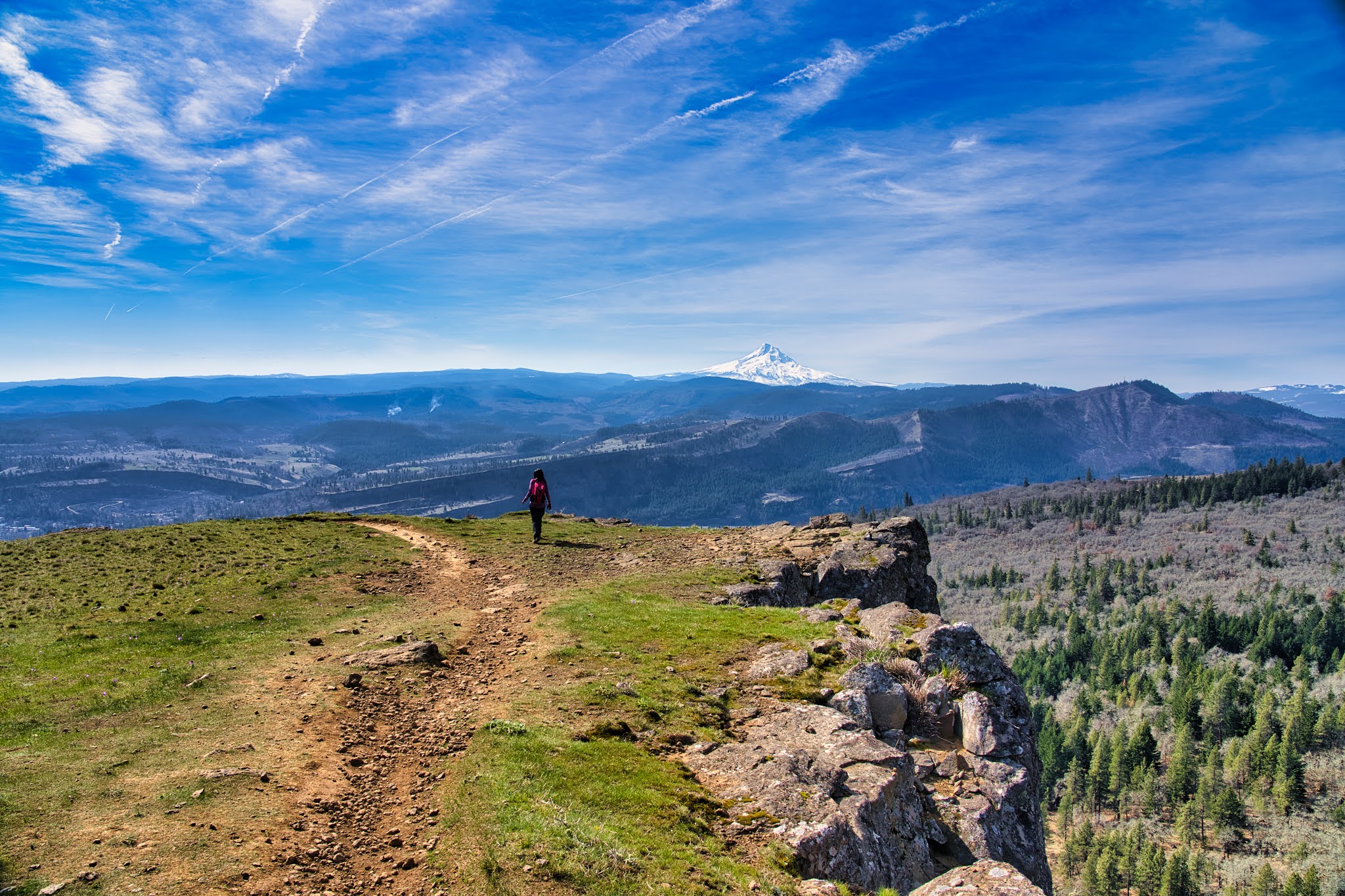
We first walked upwards and towards left, and then essentially going up the hill. As we moved across the river stream, we finally found a barely visible walking path. Thus we then followed the path to head up the hill. The climb of the hill was a bit steep, but not entirely difficult. The most wonderful thing is the view of the wildflower as we hike. There was just so much wildflower along the trail. It was so magical! This is probably the best wildflower viewing spot we have ever been to.


As we continue to head up, we eventually got to the top of the hill and there were fences blocking the private area. The fences mark the furthest we could go on the hill. We sat at the top of the hill to enjoy this beautiful view under the sun. It was extremely relaxing.


As we head back down, we could see the parking lot from the top. There were 3 more cars that arrived after us. However, as we head back down to the car, we did not run into any hikers. We figured that other people could not find the hiking trail either.


Overall, this was such an amazing hike. This hike was at a remote place and not crowded at all, but it is a gem in Pacific Northwest. If you like wildflowers, this is definitely the place to go!


Sunday, March 14, 2021

Coyote Wall


Coyote Wall is an extremely popular hiking trail on the North side of Columbia Gorge in Washington State. It is so popular because it can also be used by mountain bikers with side variety of terrains to traverse through. From Portland, it takes about 2 hours to drive to the trail head and the trail does not require any permit. The trails goes from the parking lot all the way up to the rocky hill above it with a distance of about 3 miles one way.


During this beautiful sunny March Saturday, we headed to Coyote Wall with hope to see some wild flowers. We left Portland around 7AM and got to the trail head around 9AM. Instead of taking I-84 on the Oregon side and then cross Columbia Gorge via Bridge of God, we took Highway 40 on the Washington side. It is a bit slower taking Highway 40 but it avoids the toll route.


When we got to the trail head, the parking lot was already full. So many people were here already. We had to park on the side of the road like many other people. Luckily, we did not have to park the car far and it was still within the walking distance to the trail head.


The trail head has 1 restroom for people to use. However, due to the amount of people there, there was a super long line waiting to use the restroom.


We started the hike around 9:30AM walking upwards. Many bikers were on the trail but they would slow down when they see hikers on the trail. We usually step aside to allow them to pass through first. Basically sharing the trail.


The trail also has many different routes for people to take but all of them eventually lead upwards to the top of the hill.


The trail was not difficult at all with limited elevation gain. The steeper part is after about 2 miles in. The trail starts to incline at a steeper angle, but it was not difficult either and totally doable for people of all ages.


From the top of the Coyote Wall, we could see the snow capped Mount Hood on the far side. It was such a beautiful day and Mount Hood looked like a ice cone. There were few trail paths that go near the cliff side, it was a bit scary to walk along these paths since it was very close to the cliff wall. Just be very careful when walking along the cliffs.


Overall, the trail was well maintained and dry. We had no problem sharing the path with bikers and finished the whole trail within 3 hours. There were also many people with their lovely pet dogs. Some dogs were unleashed but still well behaved. This is a highly recommend trail for wild flower viewing as well later in the season of May.

Monday, January 18, 2021

Astoria


Astoria is the most Northwestern city in Oregon state. It is located right at the mouth of Columbia River that intersects with Pacific Ocean. Astoria is also right at the border of Oregon and has a huge bridge that crosses Columbia River to Washington State. City of Astoria is about 2 hours aways from Portland. There are several breweries along the river front that allow visitors to relax along the Columbia River board walk.


On this sunny weekend, we decided to pay a visit to Astoria for the first time as we have never been there before. The drive to Astoria was rather smooth but the weather was quite foggy. As we drove on Highway 101 bridge, we were essentially driving in the fog. It was quite an unique experience.


We got to Astoria around 10AM and parked the car at Columbia River Maritime Museum. The museum is located right at the river front with plenty of parking spaces. Unfortunately the museum was temporarily closed due to the pandemic and will only re-open in February. At the back of the museum, there is a boat named Columbia docked there. It was oneof the first boat that cruised through the Columbia River. Aside from Columbia River Maritime Museum, the Astoria Coast Guard is located right beside it.

We then walked towards West along the board walk. The board walk is essentially along the historical Astoria Trolley. The old trolley rail was still in tact.


On the far side of the river, we could see several large cargo boat parked in the river in a single line. That was quite cool. We have never seen so many cargo boats together at the same time.


We then reached Astroai Megler Bridge. The bridge was way taller than what I expected. Assuming that it has to allow all the large boats to go underneath it. The bridge has bright teal colour on its truss. During the early morning, part of the bridge was essentially in the fog, which was quite cool.


Due to the pandemic, we didn't actually get to do much. We wish to re-visit this place again when everything is back to normal and open in the future.

Saturday, November 28, 2020

Drift Creek Falls


Drift Creek Falls is a popular trail with scenic waterfalls near Lincoln City in Oregon. This scenic waterfalls is about 2 hours of drive time from Portland. The hiking trail itself is 1.5 miles long 1 way with very little elevation gain. Thus the trail itself is quite easy and very family friendly. This trail is often crowded during the weekend due to its popularity, thus it is recommended to go there early in the day.


Since this Thanksgiving Black Friday was actually a sunny day, we decided to visit Drift Creek Falls. We left home around 7AM and got there around 9AM. On the way driving there, we had to drive through winding forest road in the mountain for about 25 minutes. The road was winding the narrow. We wished that we didn't have to spent so much drive time on the forest road. The good part was that most of the forest road was paved.


When we got to the parking lot, we were the third car there. The early November morning in the mountain forest was chilly and we could see the sun rays peeking through the fog. It was a beautiful site. Since it was Black Friday, no fee was needed to use the trail.


The hiking trail went downwards unlike many other trails. The trail itself was quite muddy and slippery due to the moistures in the air, but the air was extremely fresh. The trail then went around the creek and went across the creek on a wooden bridge. Once we crossed the wooden bridge, we were almost at the falls because we could hear the loud water running sound.


After about 5 minutes, we reached the suspension bridge. This suspension bridge was long and narrow. The bridge pretty much only allowed one person to go through at once. That was how narrow it was. The surface of the bridge was a bit icy and slippery. Thus we were being very careful and walking slowly to make sure we did not slip.


From the top of the bridge. we could see the falls from above. The amount of water running through the creek was breathtaking.


We then crossed the suspension bridge and headed downwards to the river side. From here we could see the falls from the bottom and also see the suspension bridge right above us. The water was icy cold!


As we depart, more people were hiking on the trail and there were cute dogs too! When we got back to the parking lot, it was already full and it was only about 10:30AM. It was a fun little hike in the morning and a nice walk outside during the weekend.

Sunday, November 1, 2020

Fort to Sea Trail


Fort to Sea Trail is a somewhat unpopular trail near the Northwest Oregon Coast. The hiking trail is about 6 miles long, so the round trip distance is 12 miles. The trail head is about 5 miles North of Seaside and people can either start the trail from the "Sea" or from the "Fort". The Fort that is referred to here is the Clatsop Fort that is built back in 1800 when Lewis and Clark ventured to the West. The trail is not as popular due to its length.


On this beautiful sunny October weekend, we decided to give this a try. We drove about 1.5 hours to get to the trail head at the "Sea" because we wanted to come back to the beach and relax there. When we got to the trail head, we saw 2 cars in front of. 1 car parked and the people in the car hopped into the other car. We were thinking that they must be heading to the Fort and just do a one way hike, which is quite a smart move.


The day was quite sunny. The first part of the trail was 2 miles towards Highway 101. The trail went through prairie land covered with tall grass. Then the trail went on a beautiful white bridge to cross Sunset Lake. The bridge was beautiful. We think it was a great spot for taking wedding photos. After the bridge, the trail cut through several cow farms.

These cow farms were so green with just few cows on it. Although it was quite smelly, we still enjoyed hiking through the farm. The trail was zig zagging through the farm and went through wooden gates to hop from 1 farm to another. Make sure you don't get lost when looking for the trail because we were quite confused on how to proceed when we hit the first wooden gate.


After going through the tunnel under Highway 101, we were starting to head upwards to Fort Clatsop. On the side of the trail, there was a farm with electrical fence, so make sure you don't touch it. There were also few snakes wondering around on the trail. We almost stepped on one of them.


The trail started to climb for the next 1.5 miles. The elevation gain was minimal but still made us to sweat. After about 30 minutes. We got to the top of the hill at the outlook. The view from here was kind of blocked by trees. So it was not the spectacular. The view point was a let down, but we were excited that we were close to Fort Clatsop.


From the outlook to Fort Clatsop was only 1.5 miles with down hill trail. We were walking quite fast and got to the Fort in 20 minutes. There weren't many people there. Due to the pandemic, the side entrance to the Fort was closed. Thus we went through the visitor center to get to the fort. Fort Clatsop was quite small and very well maintained. The bit room with the fireplace on the right was for the captain and the rooms on the left were for the others. It looked like the captain had a lot of privilege. There were also few other trails in this area along the river side and the canoe landing.


After paying a visit to Fort Clatsop, we were ready to head back to the "Sea". Heading back down to the coast was much faster and we got back within 2 hours. Along the way we also saw 2 people covered with white blankets as ghost along the trail because it was Halloween!

From the parking lot to the beach was just about 0.5 miles. The Sunset Beach was beautiful, especially with the sun setting on the West side. We saw many cars drove on the beach and people having picnic right on the sand. It was such as relaxing moment to enjoy.


The Fort to Sea trail was definitely better than what we expected. It was an easy trail with lot of change in scenery along the trail. We enjoyed it quite a lot. 12 miles round trip may sound a lot of this type of trail, but it was definitely worth the effort. If 12 miles is too long, people could always turn back after hitting Highway 101.

Sunday, October 25, 2020

Cape Meares


Cape Meares is located East of Portland on Oregon Coast near Tillamook. From Portland, it takes approximately 2 hours of drive time to get there. Cape Meares is a National Wildlife Refuge area with few easy hiking trails. At the top of Cape Meares, there is also a light house located right above the cliff near the coast line. Most of Cape Meares trails are quite easy and short. Thus the parking area is not that big because people tend to just come and go. For day use, there are few picnic tables around for people to enjoy the nature.


We drove to Cape Meares since we were visiting Tillamook Creamery that day. When we got to Cape Meares, there was not too many people. The parking lot at the top was essentially empty. From the parking lot, there was a trail the directly leads people to the light house. The trail was well paved and thus it was suitable for people with all ages.


There were few look out points along the trail with binoculars. People could use the binoculars to spot sea gulls and seals along the rocks on the coast. If you were lucky, you could also spot whales migrating along the coast.


The light house at the end of the trail was not tall. It had red coloured glass around its light. It would be a pretty sight if we came here at night to see it light up. Unfortunately, we could not enter the light house to look at it more closely either. At the bottom of the lighthouse, it seemed like there was a small gift shop there. But due to the pandemic, the gift shop is temporarily closed to avoid having crowd.


The lighthouse trail was a loop that goes all the way back to the parking lot. The trail went around the lighthouse and went along the cliff side of Cape Meares. From this side, we could see the entire Oregon coast beneath us. We could see the waves crushing towards the Oregon beach and the rain cloud was also just moving in quickly.

Overall, it was a fun trip to head out for a nice nature walk during the pandemic. We would definitely be interested to come back again to check out the inside of the lighthouse when it reopens in the future.

Sunday, September 20, 2020

Bottle Rocket


Bottle Rocket is a popular food cart located at Hawthorne Food Cart in East Portland. It serves mainly burgers with unique side and also serves homemade lemonade and various kind of beers that are brewed locally. Hawthorne Food Cart has been a popular food cart location for people in Portland and Bottle Rocket is one of the most popular choice there.


We went to Hawthorne Food Cart on Sunday to catch up with friends visiting from California. They have heard of the food cart culture in Portland and thus wanted to try as many food cart as possible. We chose Hawthorne Food Cart since it is closer and also offers good food cart experience.


Bottle Rocket is located on the East side of Hawthorne Food Cart area and the food menu includes hamburger, cheese burger, and bacon cheese burger. The sides includes various vegetable choices. People can choose to make a meal that includes the burger, a size, and a cup of homemade lemonade.


We ordered a Bacon Cheese Burger meal with Tempura Cauliflower as the side. After we placed the order, we also realized that we can choose to have bigger, or smaller burger. We chose the bigger one of course.

The burger is being cooked after the order is placed, but it was served quite fast within 10 minutes. The burger came with a large thick beef petty, which was quite juicy. There were also lettuce, onion, and pickled vegetables in the burger which provide amazing taste. A small portion of barbecue sauce was also give on the side if we wish to add more sauce in the burger.


The side was served in a Chinese takeout paper box. We were not expecting that. We chose the Tempura Cauliflower, but it was more like fried mixed vegetable. On top of cauliflower, there were also onion and jalapeno in there. There was a limited amount of cauliflower served in the box, which was a bit disappointing.


The homemade lemonade was not bad and quite refreshing.


Overall, Bottle Rocket serves great burger that's juicy and full of flavors. However, the side we chose did not meet our expectation and we would definitely try a different side next time. In addition, our friends ordered the beer from there and they loved it.

Sunday, September 6, 2020

South Sisters Summit 2020


South Sisters Summit trail is one of the most popular hiking trail at Central Oregon. South Sisters is the third tallest mountain in Oregon and there is a way to head to the top of the mountain. Every summer, thousands of hiking enthusiasts come here to do camping, day hikes, and night hikes. This hiking trail is especially crowded during the weekend. The hiking trail is about 40 minutes West from Bend and about 4 hours away from Portland. The trail is about 6 miles 1 way starting from Devil's Lake and the elevation gain is nearly 5000ft.


During the Labour Day long weekend, we decided to take Friday off and do a night hike on Thursday night since the weather is warm with low wind. We left Portland right after work and got to the trail head by 11PM. We decided to rest a bit after a long drive, thus we started the hike at 12:30AM.


When we started hiking in the first section of the trail in the forest, it was so warm and humid. We took off our jacket and outer layer to cool off. The night had a full moon in the clear sky, we barely needed to have our head lamp. The full moon was almost bright enough for us to see the trail ahead.


As we make our progress on the trail, we heard some tree branch dropping sound on the side of trail. We were alerted by this and used flash light to look around. We did not see any movement however, but suspected that there were animals around us. We stayed quite cautious as we proceeded further but did not see anything.


As we headed out of the forest, we saw a pair of shining eyes right in front of us about 15 feet away. The pair of eyes disappeared very quickly but we could clearly see our head lamp light reflecting off the eyes. We were being very careful and worried if it could be some vicious animal. For the next 10 minutes of hike, we maintained alerted status to ensure no surprises could jump at us.


After we crossed the plan and got to the rocky area, we ran into a man sleeping in a sleeping bag right on the side of the trail. Apparently we woke him up and he said he was just taking a rest. The rocky section was tiring to hike on because we had to pay close attention to where the trail was so that we would not get lost. By the time we got to Tear Drop Lake, it was around 4:30. We were hiking quite slowly compared to before.


We took a 30 minutes reset and started to make final ascend. The final part of the trail is the most difficult part. It was sandy and sipper, and the incline angle is like 60 degree. It would have been better with hiking poles but we did not carry any. It took us nearly 2 hours to complete the last part to get to the summit, but it was totally worth it.


The summit was windy but beautiful. We crossed the snow field to climb to the summit and we could see North Sister and Middle Sister. The sun rise was beautiful. It made the whole hike worth it.


Overall, this was a great hike. We do it almost every year as we enjoy this outdoor area very much. We highly recommend this hike but do prepare to carry enough water to stay hydrated.